|
search place name
|
||
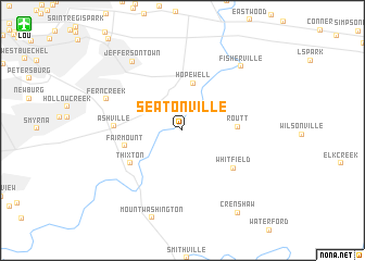
Seatonville (Kentucky, United States - USA)Seatonville is a town in the Kentucky region of United States - USA. An overview map of the region around Seatonville is displayed below.
regional and 3d topo map of Seatonville, United States - USA ::
Seatonville airports ::
The nearest airport is LOU - Louisville Bowman Fld, located 16.7 km north west of Seatonville.
Other airports nearby include FTK - Fort Knox Godman Aaf (47.0 km south west), CVG - Cincinnati Northern Kentucky Intl (126.0 km north east), LUK - Cincinnati Muni Lunken Fld (144.3 km north east), IND - Indianapolis Intl (188.6 km north), Nearby towns ::
Hopewell (4.9km north) //
Routt (4.5km east) //
Fairmount (4.9km west) //
Thixton (5.4km south west) //
Whitfield (5.7km south east) //
Ashville (5.5km west) //
Fern Creek (6.9km north west) //
Jeffersontown (8.1km north west) //
Fisherville (8.1km north east) //
Crenshaw (9.6km south east) //
[all distances 'as the bird flies' and approximate]  Places with similar names to Seatonville, United States - USA ::
// Seatonville (US)
// Stoneyville (US)
// Steinfall (DE)
// Stanghelle (NO)
// Sidneyvale (ZA)
// Stanfill (US)
// Stanville (US)
// Stoneville (US)
// Stoneville (US)
// Stoneville (US)
Disclaimer :: Information on this page comes without warranty of any kind |
||
|
Where is Seatonville? Elevation and coordinates ::
Latitude (lat): 38°7'51"N Longitude (lon): 85°31'4"W
Elevation (approx.): 156m (map arrows pan, magnifying glasses zoom) |
||
|
Visiting Seatonville? Hotel/Accommodation ::
Book a hotel in Seatonville Travel Guide ::
rental cars ::
car rental offers GPS waypoint ::
download a GPX waypoint (PoI) of Seatonville for your GPS receiver
|
||