|
search place name
|
||
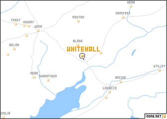
Whitehall (Louisiana, United States - USA)Whitehall is a town in the Louisiana region of United States - USA. An overview map of the region around Whitehall is displayed below.
regional and 3d topo map of Whitehall, United States - USA ::
Whitehall airports ::
The nearest airport is ESF - Alexandria Esler Rgnl, located 35.1 km south west of Whitehall.
Other airports nearby include AEX - Alexandria Intl (58.4 km south west), MLU - Monroe Rgnl (98.3 km north), POE - Fort Polk Polk Aaf (126.9 km south west), BTR - Baton Rouge Metro Ryan Fld (147.9 km south east), Nearby towns ::
 Places with similar names to Whitehall, United States - USA ::
// Haddohalle (ER)
// White Hall (US)
// White Hall (US)
// Whitehall (US)
// Whitehall (US)
// Whitehall (US)
// White Hall (US)
// White Hall (US)
// White Hill (US)
// Whitehall (US)
Disclaimer :: Information on this page comes without warranty of any kind |
||
|
Where is Whitehall? Elevation and coordinates ::
Latitude (lat): 31°37'27"N Longitude (lon): 92°2'30"W
Elevation (approx.): 32m (map arrows pan, magnifying glasses zoom) |
||
|
Visiting Whitehall? Hotel/Accommodation ::
Book a hotel in Whitehall Travel Guide ::
rental cars ::
car rental offers GPS waypoint ::
download a GPX waypoint (PoI) of Whitehall for your GPS receiver
|
||