|
search place name
|
||
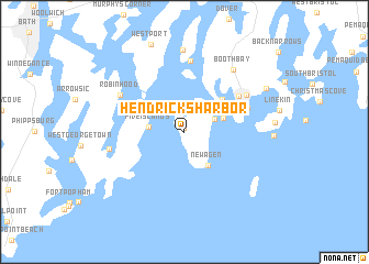
Hendricks Harbor (Maine, United States - USA)Hendricks Harbor is a town in the Maine region of United States - USA. An overview map of the region around Hendricks Harbor is displayed below.
regional and 3d topo map of Hendricks Harbor, United States - USA ::
Hendricks Harbor airports ::
The nearest airport is PWM - Portland Intl Jetport, located 54.3 km west of Hendricks Harbor.
Other airports nearby include BGR - Bangor Intl (129.0 km north east), BOS - Boston General Edward Lawrence Logan Intl (194.4 km south west), BED - Bedford Laurence G Hanscom Fld (199.1 km south west), Nearby towns ::
West Southport (0.4km north) //
Southport (2.8km north east) //
Pine Cliff (2.5km north east) //
Five Islands (2.7km west) //
MacMahan (3.4km north west) //
Newagen (3.8km south east) //
Mouse Island (3.2km north east) //
West Boothbay Harbor (4.3km north east) //
Boothbay Harbor (5.4km north east) //
Spruceworld (5.2km north east) //
Trevett (7.2km north) //
Mount Pisgah (5.8km north east) //
Robinhood (6.0km north west) //
Georgetown (5.8km west) //
Boothbay (7.2km north east) //
Oak Hill (8.4km north) //
Westport (9.2km north) //
Bayville (7.5km north east) //
[all distances 'as the bird flies' and approximate] 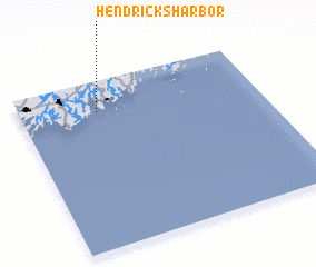 Places with similar names to Hendricks Harbor, United States - USA :: Disclaimer :: Information on this page comes without warranty of any kind |
||
|
Where is Hendricks Harbor? Elevation and coordinates ::
Latitude (lat): 43°49'11"N Longitude (lon): 69°40'43"W
Elevation (approx.): 11m (map arrows pan, magnifying glasses zoom) |
||
|
Visiting Hendricks Harbor? Hotel/Accommodation ::
Book a hotel in Hendricks Harbor Travel Guide ::
rental cars ::
car rental offers GPS waypoint ::
download a GPX waypoint (PoI) of Hendricks Harbor for your GPS receiver
|
||