|
search place name
|
||
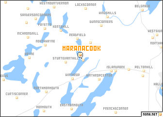
Maranacook (Maine, United States - USA)Maranacook is a town in the Maine region of United States - USA. An overview map of the region around Maranacook is displayed below.
regional and 3d topo map of Maranacook, United States - USA ::
Maranacook airports ::
The nearest airport is PWM - Portland Intl Jetport, located 82.8 km south of Maranacook.
Other airports nearby include BGR - Bangor Intl (103.3 km north east), YSC - Sherbrooke (182.9 km north west), BED - Bedford Laurence G Hanscom Fld (234.7 km south west), BOS - Boston General Edward Lawrence Logan Intl (236.0 km south), Nearby towns ::
Tallwood (0.5km south east) //
Sturtevant Hill (2.8km west) //
Readfield Depot (3.9km north) //
Readfield (4.6km north) //
Winthrop (4.9km south) //
Winthrop Center (5.5km south east) //
East Winthrop (5.7km south east) //
Kents Hill (7.3km north west) //
Island Park (6.3km south east) //
Dunns Corners (8.2km north east) //
North Wayne (6.7km north west) //
Fayette (9.1km north west) //
North Monmouth (9.6km south west) //
[all distances 'as the bird flies' and approximate]  Places with similar names to Maranacook, United States - USA ::
// Marienkoog (DE)
// Murenguko (BI)
// Murenguko (BI)
// Marangka (ID)
// Marangkee (ID)
// Muaraangke (ID)
// Meranggi 2 (ID)
// Moorngag (AU)
// Marangog (PH)
// Marungko (PH)
Disclaimer :: Information on this page comes without warranty of any kind |
||
|
Where is Maranacook? Elevation and coordinates ::
Latitude (lat): 44°20'49"N Longitude (lon): 69°57'31"W
Elevation (approx.): 87m (map arrows pan, magnifying glasses zoom) |
||
|
Visiting Maranacook? Hotel/Accommodation ::
Book a hotel in Maranacook Travel Guide ::
rental cars ::
car rental offers GPS waypoint ::
download a GPX waypoint (PoI) of Maranacook for your GPS receiver
|
||