|
search place name
|
||
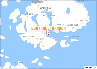
Southwest Harbor (Maine, United States - USA)Southwest Harbor is a town in the Maine region of United States - USA. An overview map of the region around Southwest Harbor is displayed below.
regional and 3d topo map of Southwest Harbor, United States - USA ::
Southwest Harbor airports ::
The nearest airport is BGR - Bangor Intl, located 71.0 km north west of Southwest Harbor.
Other airports nearby include PWM - Portland Intl Jetport (174.1 km south west), YFC - Fredericton (225.9 km north east), Nearby towns ::
Manset (1.6km south east) //
Tremont (3.6km south west) //
Northeast Harbor (3.2km north east) //
Seawall (3.8km south east) //
Bass Harbor (4.7km south) //
Wonderland (5.2km south) //
Baldwin Corners (4.5km south west) //
Bernard (4.9km south west) //
Asticou (4.4km north east) //
Hall Quarry (6.2km north) //
Richtown (5.5km south west) //
West Tremont (5.5km west) //
Cranberry Isles (6.2km south east) //
Seal Cove (5.9km west) //
Pretty Marsh (9.0km north west) //
[all distances 'as the bird flies' and approximate] 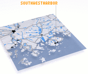 Places with similar names to Southwest Harbor, United States - USA :: Disclaimer :: Information on this page comes without warranty of any kind |
||
|
Where is Southwest Harbor? Elevation and coordinates ::
Latitude (lat): 44°16'47"N Longitude (lon): 68°19'32"W
Elevation (approx.): 17m (map arrows pan, magnifying glasses zoom) |
||
|
Visiting Southwest Harbor? Hotel/Accommodation ::
Book a hotel in Southwest Harbor Travel Guide ::
rental cars ::
car rental offers GPS waypoint ::
download a GPX waypoint (PoI) of Southwest Harbor for your GPS receiver
|
||