|
search place name
|
||
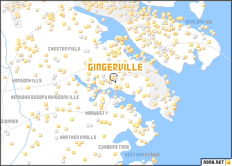
Gingerville (Maryland, United States - USA)Gingerville is a town in the Maryland region of United States - USA. An overview map of the region around Gingerville is displayed below.
regional and 3d topo map of Gingerville, United States - USA ::
Gingerville airports ::
The nearest airport is BWI - Baltimore Washington Intl, located 25.8 km north west of Gingerville.
Other airports nearby include ADW - Camp Springs Andrews Afb (Washington Dc Naf) (32.1 km south west), DCA - Ronald Reagan Washington Natl (43.9 km west), APG - Aberdeen Phillips Aaf (65.0 km north east), NHK - Patuxent River Nas (75.9 km south), Nearby towns ::
Edgewater (0.5km south) //
Gingerville Manor Estates (0.8km north) //
Ginger Cove (0.7km west) //
Donovans Pier (1.0km south) //
Poplar Point (0.9km south east) //
Gingerville Woods (1.0km north west) //
Wilelinor Estates (1.1km north east) //
Autumn Chase At Riva Trace (1.1km west) //
Bywater Estates (1.4km east) //
Chestnut Hills (1.7km south west) //
Riva Trace (1.5km west) //
Eatons Landing (1.5km east) //
Dorsey Heights (1.8km north east) //
West Woods (2.0km north) //
Cape Saint John (1.7km west) //
Pine Whiff Beach (2.3km south) //
Whiskey Bottom (2.0km north west) //
Oak Court (2.4km north) //
Edgewater Beach (2.1km south west) //
Broadview Estates (2.0km west) //
Oakbluff (2.5km south) //
The Courtyards (2.6km north) //
Threemile Oak Corner (2.8km north) //
South River Heights (2.3km south west) //
Londontown Terrace (2.9km south) //
Parole (2.6km north east) //
Loretta Heights (2.9km north east) //
Londontowne (3.1km south) //
The Ridings (2.6km south east) //
[all distances 'as the bird flies' and approximate] 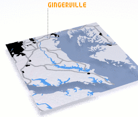 Places with similar names to Gingerville, United States - USA :: Disclaimer :: Information on this page comes without warranty of any kind |
||
|
Where is Gingerville? Elevation and coordinates ::
Latitude (lat): 38°57'41"N Longitude (lon): 76°33'3"W
Elevation (approx.): 16m (map arrows pan, magnifying glasses zoom) |
||
|
Visiting Gingerville? Hotel/Accommodation ::
Book a hotel in Gingerville Travel Guide ::
rental cars ::
car rental offers GPS waypoint ::
download a GPX waypoint (PoI) of Gingerville for your GPS receiver
|
||