|
search place name
|
||
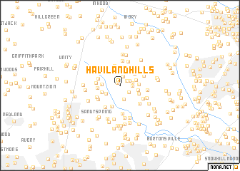
Haviland Hills (Maryland, United States - USA)Haviland Hills is a town in the Maryland region of United States - USA. An overview map of the region around Haviland Hills is displayed below.
regional and 3d topo map of Haviland Hills, United States - USA ::
Haviland Hills airports ::
The nearest airport is BWI - Baltimore Washington Intl, located 28.3 km east of Haviland Hills.
Other airports nearby include DCA - Ronald Reagan Washington Natl (38.4 km south), ADW - Camp Springs Andrews Afb (Washington Dc Naf) (44.2 km south), IAD - Washington Dulles Intl (48.7 km south west), APG - Aberdeen Phillips Aaf (77.3 km north east), Nearby towns ::
Raintree Estates (0.5km north west) //
Brighton Farm Estates (1.0km north east) //
Brighton Pines (1.4km north) //
Wood Ridge (1.4km north east) //
Green Hill Manor (1.5km south east) //
Jocelyn Acres (1.5km east) //
Chris Mar Estates (1.5km east) //
Dunfretten Estates (2.2km north) //
Swann Hills (2.2km south) //
Brighton Estates (2.1km south west) //
Waterford (2.1km north east) //
Dobridge (2.2km west) //
Allnut Farms Estates (2.3km east) //
Foxhall Villas (2.6km north east) //
Highland Lake (2.3km east) //
Brighton Knolls (2.5km south west) //
Karinwood (3.1km north) //
White Oak Estates (2.6km south east) //
Quail Hill (3.4km south) //
Brighton (2.7km west) //
Denit Estates (2.8km west) //
Hawlings View (2.9km west) //
Linden Chapel Hills (3.9km north) //
Linden Chapel Woods (3.9km north) //
Cabin Hill (3.2km north east) //
Hawlings Hills (3.4km south west) //
Brinklow (3.8km south west) //
Ashton River Estates (3.5km south west) //
Briaridge (3.7km south east) //
[all distances 'as the bird flies' and approximate]  Places with similar names to Haviland Hills, United States - USA ::
// Highland Hills (US)
// Highland Hills (US)
// Highland Hills (US)
// Highland Hills (US)
// Highland Hills (US)
// Highland Hills (US)
// Highland Hills (US)
Disclaimer :: Information on this page comes without warranty of any kind |
||
|
Where is Haviland Hills? Elevation and coordinates ::
Latitude (lat): 39°11'46"N Longitude (lon): 76°59'43"W
Elevation (approx.): 156m (map arrows pan, magnifying glasses zoom) |
||
|
Visiting Haviland Hills? Hotel/Accommodation ::
Book a hotel in Haviland Hills Travel Guide ::
rental cars ::
car rental offers GPS waypoint ::
download a GPX waypoint (PoI) of Haviland Hills for your GPS receiver
|
||