|
search place name
|
||
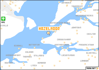
Hazelmoor (Maryland, United States - USA)Hazelmoor is a town in the Maryland region of United States - USA. An overview map of the region around Hazelmoor is displayed below.
regional and 3d topo map of Hazelmoor, United States - USA ::
Hazelmoor airports ::
The nearest airport is APG - Aberdeen Phillips Aaf, located 14.9 km north west of Hazelmoor.
Other airports nearby include ILG - Wilmington New Castle (45.8 km north east), DOV - Dover Afb (56.4 km south east), BWI - Baltimore Washington Intl (62.4 km south west), MIV - Millville Muni (81.0 km east), Nearby towns ::
Bay View Estates (2.0km north east) //
Sunset Point (2.1km north east) //
West View Shores (2.5km north east) //
Chesapeake Haven (2.4km south west) //
Cheshaven (3.1km south west) //
White Crystal Beach (4.7km north east) //
Cassidy Wharf (5.2km south east) //
Kentmore Park (6.1km south east) //
Knocks Folly (6.6km south) //
Betterton (6.6km south west) //
Brookewood Cove (7.1km south east) //
Glencoe (7.4km south east) //
Mount Harmon (7.1km south east) //
Coleman (9.6km south west) //
Locust Grove (10.5km south east) //
[all distances 'as the bird flies' and approximate]  Places with similar names to Hazelmoor, United States - USA ::
// Haslemere (GB)
Disclaimer :: Information on this page comes without warranty of any kind |
||
|
Where is Hazelmoor? Elevation and coordinates ::
Latitude (lat): 39°24'36"N Longitude (lon): 76°0'41"W
Elevation (approx.): 12m (map arrows pan, magnifying glasses zoom) |
||
|
Visiting Hazelmoor? Hotel/Accommodation ::
Book a hotel in Hazelmoor Travel Guide ::
rental cars ::
car rental offers GPS waypoint ::
download a GPX waypoint (PoI) of Hazelmoor for your GPS receiver
|
||