|
search place name
|
||
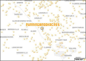
Running Brook Acres (Maryland, United States - USA)Running Brook Acres is a town in the Maryland region of United States - USA. An overview map of the region around Running Brook Acres is displayed below.
regional and 3d topo map of Running Brook Acres, United States - USA ::
Running Brook Acres airports ::
The nearest airport is IAD - Washington Dulles Intl, located 35.5 km south west of Running Brook Acres.
Other airports nearby include DCA - Ronald Reagan Washington Natl (45.9 km south east), BWI - Baltimore Washington Intl (51.6 km east), ADW - Camp Springs Andrews Afb (Washington Dc Naf) (57.5 km south east), APG - Aberdeen Phillips Aaf (98.0 km east), Nearby towns ::
Clarksburg Heights (0.3km south west) //
Clarksbrook Estates (0.9km north west) //
Greenridge Acres (1.3km south east) //
Beau Monde Estates (1.5km south) //
Fountain View (2.3km north) //
Clarksburg (2.0km north west) //
Milestone (2.3km south east) //
Brink Meadow (2.2km south east) //
Fetrows (2.4km east) //
Brink (2.7km south east) //
Henderson Corner (3.1km south east) //
Wexford (3.6km south east) //
Cedar Grove (3.3km north east) //
Meadowbrook Estates (3.9km south) //
Neelsville (3.8km south east) //
Watkins Overlook (3.2km east) //
Wilber (3.4km south west) //
Brinkwood Estates (3.6km south east) //
Miles Corner (3.7km north west) //
Cedar Grove Knolls (3.9km north east) //
Schneiders Trailer Haven (4.3km south) //
Freedom Forest (3.8km south east) //
Kingsley (4.5km north) //
Chadswood (4.3km south east) //
Cedar Heights (4.1km north east) //
Brandermill (4.8km south east) //
Kings Valley Manor (4.9km north east) //
Highview (4.5km north east) //
The Colony (5.4km south) //
[all distances 'as the bird flies' and approximate]  Places with similar names to Running Brook Acres, United States - USA :: Disclaimer :: Information on this page comes without warranty of any kind |
||
|
Where is Running Brook Acres? Elevation and coordinates ::
Latitude (lat): 39°13'35"N Longitude (lon): 77°15'45"W
Elevation (approx.): 167m (map arrows pan, magnifying glasses zoom) |
||
|
Visiting Running Brook Acres? Hotel/Accommodation ::
Book a hotel in Running Brook Acres Travel Guide ::
rental cars ::
car rental offers GPS waypoint ::
download a GPX waypoint (PoI) of Running Brook Acres for your GPS receiver
|
||