|
search place name
|
||
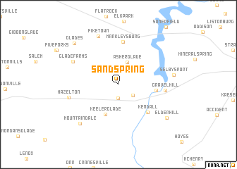
Sand Spring (Maryland, United States - USA)Sand Spring is a town in the Maryland region of United States - USA. An overview map of the region around Sand Spring is displayed below.
regional and 3d topo map of Sand Spring, United States - USA ::
Sand Spring airports ::
The nearest airport is EKN - Elkins Randolph Co Jennings Randolph, located 93.5 km south of Sand Spring.
Other airports nearby include PIT - Pittsburgh (pennsylva) Pittsburgh Intl (112.3 km north west), AOO - Altoona Blair Co (119.5 km north east), YNG - Youngstown Warren Rgnl (204.4 km north west), Nearby towns ::
Locust Grove (2.1km south) //
Blooming Rose (2.5km south east) //
Asher Glade (3.6km north) //
Keeler Glade (5.0km south) //
Friendsville (4.7km east) //
Kendall (5.6km south east) //
Markleysburg (6.8km north) //
Gravel Hill (5.8km east) //
Glade Farms (6.6km north west) //
Hazelton (6.4km west) //
Fiketown (8.0km north) //
Mountain Dale (7.7km south west) //
Selbysport (6.9km east) //
Elder Hill (7.9km south east) //
Glades (8.4km north west) //
[all distances 'as the bird flies' and approximate] 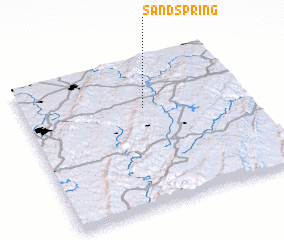 Places with similar names to Sand Spring, United States - USA ::
Disclaimer :: Information on this page comes without warranty of any kind |
||
|
Where is Sand Spring? Elevation and coordinates ::
Latitude (lat): 39°40'21"N Longitude (lon): 79°27'35"W
Elevation (approx.): 668m (map arrows pan, magnifying glasses zoom) |
||
|
Visiting Sand Spring? Hotel/Accommodation ::
Book a hotel in Sand Spring Travel Guide ::
rental cars ::
car rental offers GPS waypoint ::
download a GPX waypoint (PoI) of Sand Spring for your GPS receiver
|
||