|
search place name
|
||
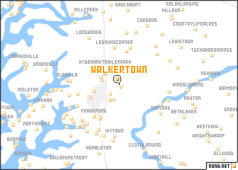
Walkertown (Maryland, United States - USA)Walkertown is a town in the Maryland region of United States - USA. An overview map of the region around Walkertown is displayed below.
regional and 3d topo map of Walkertown, United States - USA ::
Walkertown airports ::
The nearest airport is DOV - Dover Afb, located 62.0 km north east of Walkertown.
Other airports nearby include NHK - Patuxent River Nas (65.0 km south west), SBY - Salisbury Ocean City Wicomico Rgnl (67.9 km south east), BWI - Baltimore Washington Intl (69.4 km north west), ADW - Camp Springs Andrews Afb (Washington Dc Naf) (72.2 km west), Nearby towns ::
Swan Haven (0.4km south east) //
Crofton (1.7km south west) //
Chilcutt (2.4km south) //
Talbot Mobile Home Park (2.5km north west) //
West Galloway (2.2km west) //
Dover Acres (2.7km south west) //
Clearview (2.6km north west) //
Higgins (2.8km north west) //
Riser Place (2.8km north west) //
North Easton (2.6km north west) //
Hyde Park Trailer Park (3.2km north west) //
Carters Plains (3.2km north west) //
Saint Aubins Heights (3.3km west) //
Easton (4.0km south west) //
Woodland (5.4km north) //
Beechwood (5.5km south west) //
Lednums Corner (5.9km north) //
South Beechwood (5.8km south west) //
Chaple (6.1km north) //
Frankford (5.9km south west) //
North Glenwood (5.2km west) //
Providence Landing (6.1km south east) //
Woodland Farms (6.1km south west) //
Forest Gardens (6.7km north east) //
Glebe Villa (6.1km west) //
Peach Blossom Heights (7.5km south) //
Kingston Landing (6.2km east) //
Springfield (7.3km south west) //
Tanyard (6.9km south east) //
[all distances 'as the bird flies' and approximate]  Places with similar names to Walkertown, United States - USA ::
// Walkerton (US)
// Walkerton (US)
// Wuhlgarten (DE)
// Walkertown (US)
// Walkertown (US)
// Walkertown (US)
// Walkertown (US)
// Walkertown (US)
// Walkertown (US)
// Walkertown (US)
Disclaimer :: Information on this page comes without warranty of any kind |
||
|
Where is Walkertown? Elevation and coordinates ::
Latitude (lat): 38°47'30"N Longitude (lon): 76°2'10"W
Elevation (approx.): 15m (map arrows pan, magnifying glasses zoom) |
||
|
Visiting Walkertown? Hotel/Accommodation ::
Book a hotel in Walkertown Travel Guide ::
rental cars ::
car rental offers GPS waypoint ::
download a GPX waypoint (PoI) of Walkertown for your GPS receiver
|
||