|
search place name
|
||
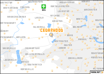
Cedarwood (Massachusetts, United States - USA)Cedarwood is a town in the Massachusetts region of United States - USA. An overview map of the region around Cedarwood is displayed below.
regional and 3d topo map of Cedarwood, United States - USA ::
nearby GPS traces from timatio ::
Cedarwood airports ::
The nearest airport is BED - Bedford Laurence G Hanscom Fld, located 11.2 km north of Cedarwood.
Other airports nearby include BOS - Boston General Edward Lawrence Logan Intl (21.3 km east), PVD - Providence Theodore Francis Green State (72.1 km south), CEF - Chicopee Falls Westover Arb Metropolitan (106.7 km west), BDL - Windsor Locks Bradley Intl (126.8 km west), Nearby towns ::
Riverview (1.5km east) //
Waltham Highlands (2.0km north east) //
Kendal Green (1.9km north west) //
Prospectville (2.8km north) //
Auburndale (2.8km south) //
Waltham (2.3km east) //
Piety Corner (2.9km north east) //
Weston Station (2.5km west) //
Hastings (2.9km north west) //
West Newton (3.4km south east) //
Lakeview (4.0km north east) //
Woodland (4.2km south east) //
Weston (3.4km west) //
Camp Cabot (4.1km north east) //
Newton Lower Falls (4.7km south) //
Beaver Brook Station (3.6km east) //
Camp Ted (4.1km north east) //
Silver Hill (4.3km north west) //
Kingston (5.2km north) //
Wellesley Farms (5.7km south) //
Clematis Brook Station (4.4km east) //
Waban (5.6km south east) //
Eastview Park (5.2km north east) //
Bemis (4.8km east) //
Grantville (6.6km south) //
Nonantum (5.0km east) //
Newtonville (5.4km south east) //
Idylwide (7.0km north) //
Newton (5.8km south east) //
[all distances 'as the bird flies' and approximate]  Places with similar names to Cedarwood, United States - USA ::
// Cedarwood (US)
// Cedarwood (US)
// Cedarwood (US)
// Cedarwood (US)
// Cedarwood (US)
// Cedarwood (US)
// Zoeterwoude (NL)
// Zuiderwoude (NL)
// Starwood (TT)
Disclaimer :: Information on this page comes without warranty of any kind |
||
|
Where is Cedarwood? Elevation and coordinates ::
Latitude (lat): 42°22'15"N Longitude (lon): 71°15'47"W
Elevation (approx.): 65m (map arrows pan, magnifying glasses zoom) |
||
|
Visiting Cedarwood? Hotel/Accommodation ::
Book a hotel in Cedarwood Travel Guide ::
rental cars ::
car rental offers GPS waypoint ::
download a GPX waypoint (PoI) of Cedarwood for your GPS receiver
|
||