|
search place name
|
||
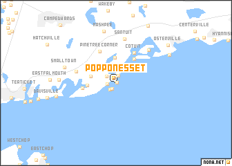
Popponesset (Massachusetts, United States - USA)Popponesset is a town in the Massachusetts region of United States - USA. An overview map of the region around Popponesset is displayed below.
regional and 3d topo map of Popponesset, United States - USA ::
Popponesset airports ::
The nearest airport is ACK - Nantucket Mem, located 49.0 km south east of Popponesset.
Other airports nearby include PVD - Providence Theodore Francis Green State (81.6 km west), BOS - Boston General Edward Lawrence Logan Intl (98.7 km north west), BED - Bedford Laurence G Hanscom Fld (120.8 km north west), Nearby towns ::
Popponesset Beach (0.1km east) //
Rock Landing (1.0km south west) //
Popponesset Island (1.2km north) //
New Seabury (1.0km west) //
Maushop Village (1.2km south west) //
South Mashpee (1.5km north west) //
Mashpee Neck (4.1km north) //
Seabrook (3.2km west) //
Monomoscoy Island (3.5km west) //
Cotuit Highlands (4.5km north east) //
Seconsett Island (4.1km west) //
Cotuit (5.3km north east) //
Pine Tree Corner (5.4km north) //
Waquoit Village (5.2km west) //
Santuit (7.2km north) //
Oyster Harbors (6.6km north east) //
Mashpee (8.5km north) //
Smalltown (6.7km west) //
Wianno (7.9km north east) //
Osterville (8.8km north east) //
[all distances 'as the bird flies' and approximate] 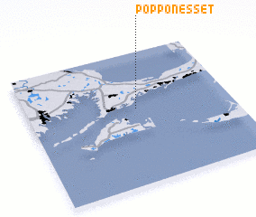 Places with similar names to Popponesset, United States - USA :: Disclaimer :: Information on this page comes without warranty of any kind |
||
|
Where is Popponesset? Elevation and coordinates ::
Latitude (lat): 41°34'24"N Longitude (lon): 70°27'49"W
Elevation (approx.): 3m (map arrows pan, magnifying glasses zoom) |
||
|
Visiting Popponesset? Hotel/Accommodation ::
Book a hotel in Popponesset Travel Guide ::
rental cars ::
car rental offers GPS waypoint ::
download a GPX waypoint (PoI) of Popponesset for your GPS receiver
|
||