|
search place name
|
||
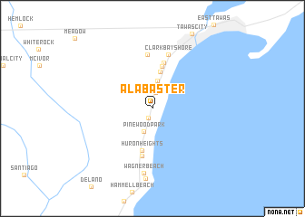
Alabaster (Michigan, United States - USA)Alabaster is a town in the Michigan region of United States - USA. An overview map of the region around Alabaster is displayed below.
regional and 3d topo map of Alabaster, United States - USA ::
Alabaster airports ::
The nearest airport is YZR - Sarnia Chris Hadfield, located 166.0 km south east of Alabaster.
Other airports nearby include LAN - Lansing Capital City (177.2 km south west), MTC - Mount Clemens Selfridge Angb (184.8 km south), DET - Detroit Coleman A Young Muni (202.4 km south), YZE - Gore Bay Manitoulin (204.3 km north), Nearby towns ::
Cedar Haven (1.2km south) //
Benson Park (1.9km north) //
Oak Wood Shores (2.8km north) //
Pine Wood Park (2.9km south) //
Hyde Park (3.4km north) //
Huron Oaks (4.6km north) //
Huron Heights (5.2km south) //
Lake Huron Beach (5.3km north) //
Anderson Bayview (5.7km north) //
Harmon City Heights (5.9km south) //
Alabaster Junction (6.6km north) //
Clark Bayshore (6.8km north) //
Wagner Beach (8.0km south) //
Whitestone Point (8.7km south) //
[all distances 'as the bird flies' and approximate] 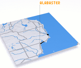 Places with similar names to Alabaster, United States - USA ::
Disclaimer :: Information on this page comes without warranty of any kind |
||
|
Where is Alabaster? Elevation and coordinates ::
Latitude (lat): 44°11'11"N Longitude (lon): 83°33'29"W
Elevation (approx.): 183m (map arrows pan, magnifying glasses zoom) |
||
|
Visiting Alabaster? Hotel/Accommodation ::
Book a hotel in Alabaster Travel Guide ::
rental cars ::
car rental offers GPS waypoint ::
download a GPX waypoint (PoI) of Alabaster for your GPS receiver
|
||