|
search place name
|
||
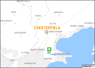
Chesterfield (Michigan, United States - USA)Chesterfield is a town in the Michigan region of United States - USA. An overview map of the region around Chesterfield is displayed below.
regional and 3d topo map of Chesterfield, United States - USA ::
Chesterfield airports ::
The nearest airport is MTC - Mount Clemens Selfridge Angb, located 6.1 km south of Chesterfield.
Other airports nearby include DET - Detroit Coleman A Young Muni (31.3 km south west), YQG - Windsor (44.0 km south), YZR - Sarnia Chris Hadfield (57.5 km north east), DTW - Detroit Metro Wayne Co (65.3 km south west), Nearby towns ::
Sebille Manor (2.5km east) //
Milton (3.4km north east) //
Anchor Bay Gardens (3.3km south east) //
Anchor Bay Shores (3.7km south east) //
Anchor Bay Harbor (3.6km east) //
Meade (6.6km north west) //
Point Lakeview (5.2km east) //
Mount Clemens (7.8km south) //
New Haven (8.1km north east) //
Saint Clair Haven (9.8km south east) //
Clinton (10.6km south west) //
[all distances 'as the bird flies' and approximate] 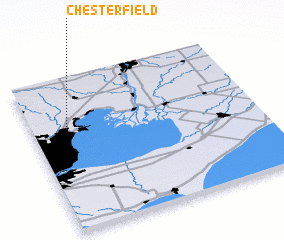 Places with similar names to Chesterfield, United States - USA ::
// Chesterfield (US)
// Chesterfield (US)
// Chesterfield (US)
// Chesterfield (US)
// Chesterfield (US)
// Chesterfield (NZ)
// Chesterfield (US)
// Chesterfield (US)
// Chesterfield (US)
// Chesterfield (US)
Disclaimer :: Information on this page comes without warranty of any kind |
||
|
Where is Chesterfield? Elevation and coordinates ::
Latitude (lat): 42°39'46"N Longitude (lon): 82°50'33"W
Elevation (approx.): 184m (map arrows pan, magnifying glasses zoom) |
||
|
Visiting Chesterfield? Hotel/Accommodation ::
Book a hotel in Chesterfield Travel Guide ::
rental cars ::
car rental offers GPS waypoint ::
download a GPX waypoint (PoI) of Chesterfield for your GPS receiver
|
||