|
search place name
|
||
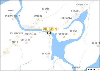
Pilgrim (Michigan, United States - USA)Pilgrim is a town in the Michigan region of United States - USA. An overview map of the region around Pilgrim is displayed below.
regional and 3d topo map of Pilgrim, United States - USA ::
Pilgrim airports ::
The nearest airport is YQT - Thunder Bay, located 153.9 km north west of Pilgrim.
Nearby towns ::
Sunshine Beach (1.2km south) //
Dollar Bay (2.3km north) //
Ripley (4.1km north west) //
Point Mills (3.5km east) //
Houghton (4.6km north west) //
Paavola (6.0km north) //
Hurontown (4.5km west) //
Pewabic (5.7km north west) //
Dodgeville (4.9km west) //
Mason (6.0km north east) //
Lewer Pewabic (6.6km north west) //
Arcadian (6.9km north west) //
Franklin Mine (6.2km north west) //
Hancock (5.7km north west) //
Chassell (8.0km south) //
Quincy Mill (7.0km north east) //
Boston (8.9km north) //
[all distances 'as the bird flies' and approximate] 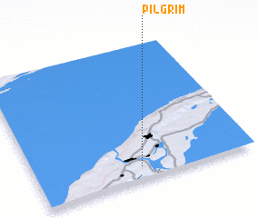 Places with similar names to Pilgrim, United States - USA ::
// Pillgram (DE)
// Pilgrim (US)
// Pilgrim (US)
// Pilgrim (US)
// Pilgrim (US)
// Palagouroum (TD)
// Pulaukaram (ID)
// Pyl'-Karamo (RU)
// Pơlei Kram (VN)
Disclaimer :: Information on this page comes without warranty of any kind |
||
|
Where is Pilgrim? Elevation and coordinates ::
Latitude (lat): 47°5'59"N Longitude (lon): 88°31'1"W
Elevation (approx.): 193m (map arrows pan, magnifying glasses zoom) |
||
|
Visiting Pilgrim? Hotel/Accommodation ::
Book a hotel in Pilgrim Travel Guide ::
rental cars ::
car rental offers GPS waypoint ::
download a GPX waypoint (PoI) of Pilgrim for your GPS receiver
|
||