|
search place name
|
||
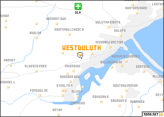
West Duluth (Minnesota, United States - USA)West Duluth is a town in the Minnesota region of United States - USA. An overview map of the region around West Duluth is displayed below.
regional and 3d topo map of West Duluth, United States - USA ::
West Duluth airports ::
The nearest airport is DLH - Duluth Intl, located 11.9 km north of West Duluth.
Other airports nearby include HIB - Chisholm Hibbing (87.7 km north west), MSP - Minneapolis St Paul Intl (221.2 km south), INL - International Falls Falls Intl (223.1 km north west), Nearby towns ::
Bayview (1.5km north west) //
Oneota (2.0km north east) //
Riverside (3.1km south west) //
Proctor (3.3km north west) //
Smithville (4.2km south west) //
Morgan Park (5.6km south) //
Saint Paul Church (5.8km north) //
Riverview (6.6km south) //
Missabe Junction (5.1km north east) //
Billings Park (5.1km east) //
Steelton (7.7km south) //
Gary (7.9km south west) //
Oliver (8.7km south) //
Duluth Heights (8.4km north east) //
New Duluth (8.9km south) //
Hermantown (8.9km north west) //
Duluth (8.1km north east) //
[all distances 'as the bird flies' and approximate] 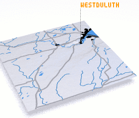 Places with similar names to West Duluth, United States - USA :: Disclaimer :: Information on this page comes without warranty of any kind |
||
|
Where is West Duluth? Elevation and coordinates ::
Latitude (lat): 46°44'8"N Longitude (lon): 92°11'10"W
Elevation (approx.): 213m (map arrows pan, magnifying glasses zoom) |
||
|
Visiting West Duluth? Hotel/Accommodation ::
Book a hotel in West Duluth Travel Guide ::
rental cars ::
car rental offers GPS waypoint ::
download a GPX waypoint (PoI) of West Duluth for your GPS receiver
|
||