|
search place name
|
||
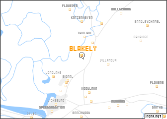
Blakely (Mississippi, United States - USA)Blakely is a town in the Mississippi region of United States - USA. An overview map of the region around Blakely is displayed below.
regional and 3d topo map of Blakely, United States - USA ::
Blakely airports ::
The nearest airport is JAN - Jackson Evers Intl, located 71.8 km east of Blakely.
Other airports nearby include MLU - Monroe Rgnl (114.5 km west), GWO - Greenwood Leflore (135.4 km north east), ESF - Alexandria Esler Rgnl (181.5 km south west), AEX - Alexandria Intl (205.0 km south west), Nearby towns ::
Redwood (4.2km north east) //
Twin Lake (5.0km north) //
Villanova (4.8km east) //
Signal (5.6km south west) //
Kings (6.1km south west) //
Valley Mills (6.9km south west) //
Woodlawn (7.6km south) //
Long Lake (6.9km south west) //
Culkin (8.4km south) //
Katzenmeyer (8.6km north) //
Waltersville (8.3km south west) //
Haynes Bluff (8.8km north east) //
[all distances 'as the bird flies' and approximate]  Places with similar names to Blakely, United States - USA ::
Disclaimer :: Information on this page comes without warranty of any kind |
||
|
Where is Blakely? Elevation and coordinates ::
Latitude (lat): 32°26'37"N Longitude (lon): 90°49'20"W
Elevation (approx.): 34m (map arrows pan, magnifying glasses zoom) |
||
|
Visiting Blakely? Hotel/Accommodation ::
Book a hotel in Blakely Travel Guide ::
rental cars ::
car rental offers GPS waypoint ::
download a GPX waypoint (PoI) of Blakely for your GPS receiver
|
||