|
search place name
|
||
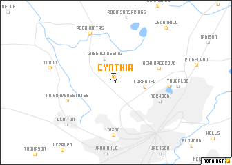
Cynthia (Mississippi, United States - USA)Cynthia is a town in the Mississippi region of United States - USA. An overview map of the region around Cynthia is displayed below.
regional and 3d topo map of Cynthia, United States - USA ::
Cynthia airports ::
The nearest airport is JAN - Jackson Evers Intl, located 19.2 km south east of Cynthia.
Other airports nearby include GWO - Greenwood Leflore (122.0 km north), NMM - Meridian Nas (160.0 km east), MLU - Monroe Rgnl (168.6 km west), CBM - Colombus Columbus Afb (217.7 km north east), Nearby towns ::
Green Crossing (4.2km north) //
Lakeover (4.0km east) //
New Hope Grove (6.3km east) //
Norwood (6.7km south east) //
Pinehaven Estates (7.2km south west) //
North Colony (7.2km east) //
Dixon (8.6km south) //
Pocahontas (8.7km north west) //
Clinton (9.7km south west) //
[all distances 'as the bird flies' and approximate]  Places with similar names to Cynthia, United States - USA ::
Disclaimer :: Information on this page comes without warranty of any kind |
||
|
Where is Cynthia? Elevation and coordinates ::
Latitude (lat): 32°24'10"N Longitude (lon): 90°14'56"W
Elevation (approx.): 105m (map arrows pan, magnifying glasses zoom) |
||
|
Visiting Cynthia? Hotel/Accommodation ::
Book a hotel in Cynthia Travel Guide ::
rental cars ::
car rental offers GPS waypoint ::
download a GPX waypoint (PoI) of Cynthia for your GPS receiver
|
||