|
search place name
|
||
Mount Herman (Mississippi, United States - USA)Mount Herman is a town in the Mississippi region of United States - USA. An overview map of the region around Mount Herman is displayed below.
regional and 3d topo map of Mount Herman, United States - USA ::

Mount Herman airports ::
The nearest airport is GWO - Greenwood Leflore, located 46.4 km north west of Mount Herman.
Other airports nearby include JAN - Jackson Evers Intl (107.2 km south), CBM - Colombus Columbus Afb (125.9 km east), NMM - Meridian Nas (130.8 km south east), MEM - Memphis Intl (203.1 km north), Nearby towns ::
Carmack (4.1km north east) //
Rocky Point (6.3km south) //
Beatty (6.0km north west) //
West (7.6km south west) //
Hesterville (8.5km south east) //
[all distances 'as the bird flies' and approximate] 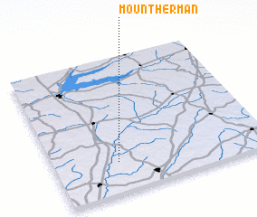 Places with similar names to Mount Herman, United States - USA ::
// Mount Herman (US)
// Mount Hermon (US)
// Mount Hermon (US)
// Mount Harmon (US)
// Mount Harmony (US)
// Mount Hermon (US)
// Mount Hermon (US)
// Mount Herman (US)
// Mount Herman (US)
// Mount Herman (US)
Disclaimer :: Information on this page comes without warranty of any kind |
||
|
Where is Mount Herman? Elevation and coordinates ::
Latitude (lat): 33°13'31"N Longitude (lon): 89°42'10"W
Elevation (approx.): 105m (map arrows pan, magnifying glasses zoom) |
||
|
Visiting Mount Herman? Hotel/Accommodation ::
Book a hotel in Mount Herman Travel Guide ::
rental cars ::
car rental offers GPS waypoint ::
download a GPX waypoint (PoI) of Mount Herman for your GPS receiver
|
||