|
search place name
|
||
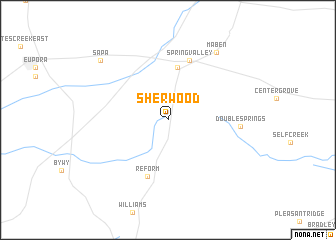
Sherwood (Mississippi, United States - USA)Sherwood is a town in the Mississippi region of United States - USA. An overview map of the region around Sherwood is displayed below.
regional and 3d topo map of Sherwood, United States - USA ::
Sherwood airports ::
The nearest airport is CBM - Colombus Columbus Afb, located 66.4 km east of Sherwood.
Other airports nearby include GWO - Greenwood Leflore (88.4 km west), NMM - Meridian Nas (117.0 km south east), JAN - Jackson Evers Intl (157.5 km south west), MEM - Memphis Intl (189.1 km north west), Nearby towns ::
Mathiston (5.9km north) //
Reform (6.6km south) //
Spring Valley (6.9km north) //
Double Springs (6.8km east) //
Maben (8.8km north east) //
Sapa (9.2km north west) //
[all distances 'as the bird flies' and approximate] 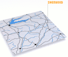 Places with similar names to Sherwood, United States - USA ::
// Sherwood (US)
// Sherwood (US)
// Shorewood (US)
// Cherrywood (US)
// Cherrywood (US)
// Sherwood (US)
// Shorewood (US)
// Sharwīdah (EG)
// Sherwood (ZA)
// Sherwood (US)
Disclaimer :: Information on this page comes without warranty of any kind |
||
|
Where is Sherwood? Elevation and coordinates ::
Latitude (lat): 33°29'16"N Longitude (lon): 89°8'2"W
Elevation (approx.): 149m (map arrows pan, magnifying glasses zoom) |
||
|
Visiting Sherwood? Hotel/Accommodation ::
Book a hotel in Sherwood Travel Guide ::
rental cars ::
car rental offers GPS waypoint ::
download a GPX waypoint (PoI) of Sherwood for your GPS receiver
|
||