|
search place name
|
||
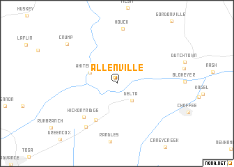
Allenville (Missouri, United States - USA)Allenville is a town in the Missouri region of United States - USA. An overview map of the region around Allenville is displayed below.
regional and 3d topo map of Allenville, United States - USA ::
Allenville airports ::
The nearest airport is BYH - Blytheville Arkansas Intl, located 140.5 km south of Allenville.
Other airports nearby include BLV - Belleville Scott Afb Midamerica (147.1 km north), JBR - Jonesboro Muni (173.6 km south west), STL - St. Louis Lambert St Louis Intl (177.8 km north), MKL - Jackson Mc Kellar Sipes Rgnl (195.2 km south east), Nearby towns ::
Delta (3.4km south east) //
Whitewater (3.8km north west) //
Cliff (6.5km south west) //
Hickory Ridge (6.8km south west) //
Arbor (8.0km south west) //
Houck (8.8km north) //
Crump (9.0km north west) //
[all distances 'as the bird flies' and approximate] 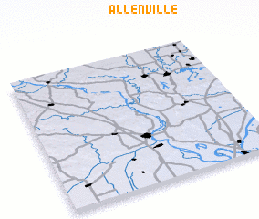 Places with similar names to Allenville, United States - USA ::
// Allenville (US)
// Allenville (US)
// Allenville (US)
// Allenvale (US)
// Aillianville (FR)
// Allonville (FR)
// Allainville (FR)
// Allainville (FR)
// Allonville (FR)
// Alanvale (AU)
Disclaimer :: Information on this page comes without warranty of any kind |
||
|
Where is Allenville? Elevation and coordinates ::
Latitude (lat): 37°13'18"N Longitude (lon): 89°45'27"W
Elevation (approx.): 106m (map arrows pan, magnifying glasses zoom) |
||
|
Visiting Allenville? Hotel/Accommodation ::
Book a hotel in Allenville Travel Guide ::
rental cars ::
car rental offers GPS waypoint ::
download a GPX waypoint (PoI) of Allenville for your GPS receiver
|
||