|
search place name
|
||
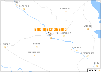
Browns Crossing (Missouri, United States - USA)Browns Crossing is a town in the Missouri region of United States - USA. An overview map of the region around Browns Crossing is displayed below.
regional and 3d topo map of Browns Crossing, United States - USA ::
Browns Crossing airports ::
The nearest airport is BYH - Blytheville Arkansas Intl, located 126.1 km south east of Browns Crossing.
Other airports nearby include JBR - Jonesboro Muni (126.6 km south), TBN - Fort Leonardwood Waynesville Rgnl Arpt At Forney Fld (161.4 km north west), BLV - Belleville Scott Afb Midamerica (187.0 km north), NQA - Millington Rgnl Jetport (190.7 km south), Nearby towns ::
Bull Run Camp (0.7km south) //
Williamsville (4.0km east) //
Upalika (5.6km south west) //
Keener Cave (7.8km south east) //
Brush Arbor (8.6km south west) //
[all distances 'as the bird flies' and approximate] 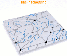 Places with similar names to Browns Crossing, United States - USA ::
// Browns Crossing (US)
// Browns Crossing (US)
// Browns Crossing (US)
// Browns Crossing (US)
// Byrnes Crossing (US)
Disclaimer :: Information on this page comes without warranty of any kind |
||
|
Where is Browns Crossing? Elevation and coordinates ::
Latitude (lat): 36°58'19"N Longitude (lon): 90°35'41"W
Elevation (approx.): 121m (map arrows pan, magnifying glasses zoom) |
||
|
Visiting Browns Crossing? Hotel/Accommodation ::
Book a hotel in Browns Crossing Travel Guide ::
rental cars ::
car rental offers GPS waypoint ::
download a GPX waypoint (PoI) of Browns Crossing for your GPS receiver
|
||