|
search place name
|
||
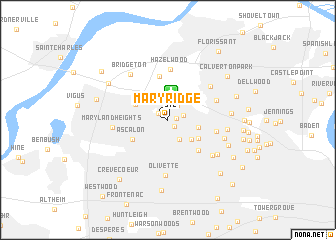
Mary Ridge (Missouri, United States - USA)Mary Ridge is a town in the Missouri region of United States - USA. An overview map of the region around Mary Ridge is displayed below.
regional and 3d topo map of Mary Ridge, United States - USA ::
Mary Ridge airports ::
The nearest airport is STL - St. Louis Lambert St Louis Intl, located 3.1 km north of Mary Ridge.
Other airports nearby include BLV - Belleville Scott Afb Midamerica (50.8 km east), COU - Columbia Rgnl (160.8 km west), TBN - Fort Leonardwood Waynesville Rgnl Arpt At Forney Fld (189.1 km south west), Nearby towns ::
Schuermann Heights (0.8km east) //
Breckenridge Hills (0.9km south east) //
Saint Ann (1.1km north west) //
Woodson Terrace (1.4km east) //
Edmundson (1.9km north east) //
Overland (2.4km south east) //
Bridgeton Terrace (3.1km north) //
Sycamore Hills (3.0km south east) //
Saint Johns (2.8km east) //
Charlack (3.3km south east) //
Pattonville (3.3km north west) //
Ascalon (3.8km south west) //
Vinita Park (4.4km south east) //
Robertson (4.9km north) //
Bel-Ridge (4.4km east) //
Hazelwood (5.6km north) //
Kinloch (4.7km north east) //
Berkeley (5.2km north east) //
Olivette (6.2km south) //
Maryland Heights (4.9km west) //
Vinita Terrace (5.5km south east) //
Bridgeton (6.1km north west) //
Bel-Nor (5.4km south east) //
Bellerive (5.3km east) //
Hanley Hills (5.8km south east) //
Cool Valley (5.6km east) //
Greendale (6.0km south east) //
Natural Bridge Junction (6.6km north west) //
Ladue (7.9km south) //
[all distances 'as the bird flies' and approximate] 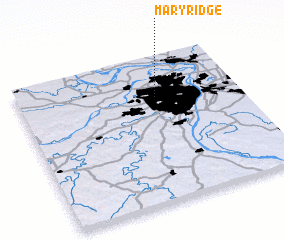 Places with similar names to Mary Ridge, United States - USA ::
// Moraraja (MG)
// Mare Rouge (HT)
// Mare Rouge (HT)
// Mare Rouge (HT)
// Mare Rouge (HT)
// Mare Rouge (HT)
// Mare Rouge (HT)
// Mare Rouge (HT)
// Mare Rouge (HT)
// Mare Rouge (HT)
Disclaimer :: Information on this page comes without warranty of any kind |
||
|
Where is Mary Ridge? Elevation and coordinates ::
Latitude (lat): 38°43'15"N Longitude (lon): 90°22'25"W
Elevation (approx.): 181m (map arrows pan, magnifying glasses zoom) |
||
|
Visiting Mary Ridge? Hotel/Accommodation ::
Book a hotel in Mary Ridge Travel Guide ::
rental cars ::
car rental offers GPS waypoint ::
download a GPX waypoint (PoI) of Mary Ridge for your GPS receiver
|
||