|
search place name
|
||
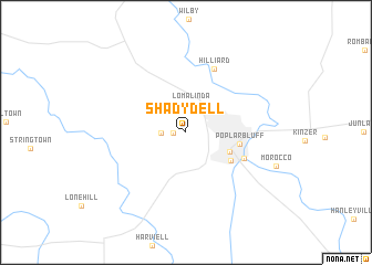
Shady Dell (Missouri, United States - USA)Shady Dell is a town in the Missouri region of United States - USA. An overview map of the region around Shady Dell is displayed below.
regional and 3d topo map of Shady Dell, United States - USA ::
Shady Dell airports ::
The nearest airport is BYH - Blytheville Arkansas Intl, located 99.7 km south east of Shady Dell.
Other airports nearby include JBR - Jonesboro Muni (105.5 km south), NQA - Millington Rgnl Jetport (164.8 km south), TBN - Fort Leonardwood Waynesville Rgnl Arpt At Forney Fld (185.5 km north west), MKL - Jackson Mc Kellar Sipes Rgnl (188.8 km south east), Nearby towns ::
Cedar Valley (1.0km west) //
Green Forest (2.1km west) //
Loma Linda (2.9km north) //
Kelly Town (4.0km south east) //
Vinegar Hill (4.6km south east) //
Poplar Bluff (4.5km east) //
Ashcroft Addition (5.4km south east) //
Hilliard (6.8km north) //
[all distances 'as the bird flies' and approximate] 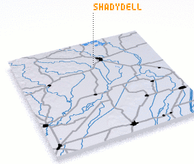 Places with similar names to Shady Dell, United States - USA ::
// Shady Dell (US)
// Shady Dale (US)
// Shady Dale (US)
// Shady Dell (US)
// Shady Dell (US)
// Chhota Tula (BD)
// Chhatti Tāhli (IN)
// Chiatitla (MX)
// Shady Dell (US)
Disclaimer :: Information on this page comes without warranty of any kind |
||
|
Where is Shady Dell? Elevation and coordinates ::
Latitude (lat): 36°46'4"N Longitude (lon): 90°26'31"W
Elevation (approx.): 123m (map arrows pan, magnifying glasses zoom) |
||
|
Visiting Shady Dell? Hotel/Accommodation ::
Book a hotel in Shady Dell Travel Guide ::
rental cars ::
car rental offers GPS waypoint ::
download a GPX waypoint (PoI) of Shady Dell for your GPS receiver
|
||