|
search place name
|
||
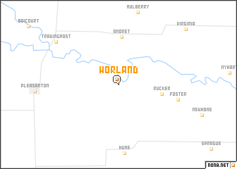
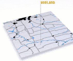
Worland (Missouri, United States - USA)Worland is a town in the Missouri region of United States - USA. An overview map of the region around Worland is displayed below.
regional and 3d topo map of Worland, United States - USA ::
Worland airports ::
The nearest airport is SZL - Knobnoster Whiteman Afb, located 109.2 km north east of Worland.
Other airports nearby include MCI - Kansas City Intl (123.7 km north), FOE - Topeka Forbes Fld (126.1 km north west), FLV - Fort Leavenworth Sherman Aaf (134.0 km north), HRO - Harrison Boone Co (248.9 km south east), Nearby towns ::
 Places with similar names to Worland, United States - USA ::
// Wareland (US)
// Wehrland (DE)
// Warrlinda (US)
// Waralanda (LK)
// Warralande (LK)
// Weralanda (LK)
// Wara Lundai (PK)
// Wuro Lainde (NG)
// Wuro Lainde (NG)
// Wuro Lainde (NG)
Disclaimer :: Information on this page comes without warranty of any kind |
||
|
Where is Worland? Elevation and coordinates ::
Latitude (lat): 38°11'16"N Longitude (lon): 94°35'30"W
Elevation (approx.): 255m (map arrows pan, magnifying glasses zoom) |
||
|
Visiting Worland? Hotel/Accommodation ::
Book a hotel in Worland Travel Guide ::
rental cars ::
car rental offers GPS waypoint ::
download a GPX waypoint (PoI) of Worland for your GPS receiver
|
||