|
search place name
|
||
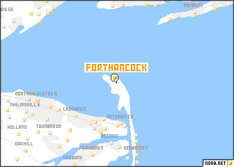
Fort Hancock (New Jersey, United States - USA)Fort Hancock is a town in the New Jersey region of United States - USA. An overview map of the region around Fort Hancock is displayed below.
regional and 3d topo map of Fort Hancock, United States - USA ::
Fort Hancock airports ::
The nearest airport is JFK - New York John F Kennedy Intl, located 27.2 km north east of Fort Hancock.
Other airports nearby include EWR - Newark Liberty Intl (29.0 km north west), LGA - New York La Guardia (36.5 km north), TEB - Teterboro (43.2 km north), NEL - Lakehurst Naes (56.3 km south west), Nearby towns ::
Hilton (6.0km south) //
Waterwitch (6.4km south) //
Monmouth Hills (6.8km south) //
Highlands (6.8km south) //
Atlantic Highlands (6.8km south west) //
Stone Church (7.5km south) //
Leonardville (7.2km south west) //
Navesink (7.7km south) //
Locust (8.0km south) //
Leonardo (7.2km south west) //
Navesink Beach (8.6km south) //
Chapel Hill (9.4km south west) //
[all distances 'as the bird flies' and approximate] 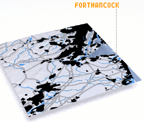 Places with similar names to Fort Hancock, United States - USA ::
// Fort Hancock (US)
Disclaimer :: Information on this page comes without warranty of any kind |
||
|
Where is Fort Hancock? Elevation and coordinates ::
Latitude (lat): 40°27'50"N Longitude (lon): 74°0'11"W
Elevation (approx.): 2m (map arrows pan, magnifying glasses zoom) |
||
|
Visiting Fort Hancock? Hotel/Accommodation ::
Book a hotel in Fort Hancock Travel Guide ::
rental cars ::
car rental offers GPS waypoint ::
download a GPX waypoint (PoI) of Fort Hancock for your GPS receiver
|
||