|
search place name
|
||
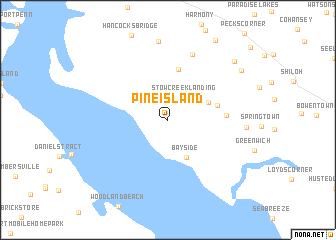
Pine Island (New Jersey, United States - USA)Pine Island is a town in the New Jersey region of United States - USA. An overview map of the region around Pine Island is displayed below.
regional and 3d topo map of Pine Island, United States - USA ::
Pine Island airports ::
The nearest airport is MIV - Millville Muni, located 31.0 km east of Pine Island.
Other airports nearby include DOV - Dover Afb (32.5 km south), ILG - Wilmington New Castle (32.6 km north west), PHL - Philadelphia Intl (52.6 km north), WWD - Wildwood Cape May Co (63.9 km south east), Nearby towns ::
Stow Creek Landing (2.9km north east) //
Bay Side (4.5km south) //
Garrison Corner (4.1km north east) //
Gum Tree Corner (4.0km north east) //
Willis Corner (4.5km east) //
Canton (5.7km north) //
Davis Mill (5.1km east) //
Maskells Mill (7.6km north) //
Othello (6.8km east) //
Harmersville (8.8km north) //
Schepps Valley (8.7km north east) //
Jericho (8.4km north east) //
Woods Upper Mill (9.7km north east) //
[all distances 'as the bird flies' and approximate]  Places with similar names to Pine Island, United States - USA ::
// Pine Island (US)
// Pine Island (US)
// Pine Island (US)
// Pine Island (US)
// Pine Island (US)
// Pine Island (US)
// Pine Island (US)
// Pine Island (US)
// Pine Island (US)
Disclaimer :: Information on this page comes without warranty of any kind |
||
|
Where is Pine Island? Elevation and coordinates ::
Latitude (lat): 39°25'13"N Longitude (lon): 75°25'32"W
(map arrows pan, magnifying glasses zoom) |
||
|
Visiting Pine Island? Hotel/Accommodation ::
Book a hotel in Pine Island Travel Guide ::
rental cars ::
car rental offers GPS waypoint ::
download a GPX waypoint (PoI) of Pine Island for your GPS receiver
|
||