|
search place name
|
||
Port Republic (New Jersey, United States - USA)Port Republic is a town in the New Jersey region of United States - USA. An overview map of the region around Port Republic is displayed below.
regional and 3d topo map of Port Republic, United States - USA ::

Port Republic airports ::
The nearest airport is ACY - Atlantic City Intl, located 10.5 km south west of Port Republic.
Other airports nearby include MIV - Millville Muni (53.2 km west), WRI - Wrightstown Mc Guire Afb (55.7 km north), NEL - Lakehurst Naes (58.1 km north), WWD - Wildwood Cape May Co (67.5 km south west), Nearby towns ::
Unionville (1.5km north west) //
Clarks Mill (1.8km west) //
Johnsontown (2.2km east) //
Higbeeville (2.6km east) //
Smithville (3.8km south east) //
Oceanville (5.9km south) //
Leeds Point (5.8km south east) //
Oyster Creek (6.2km east) //
Absecon Highlands (8.3km south) //
Clarks Landing (7.5km north west) //
Pinehurst (7.2km south west) //
Seaview Park (8.7km south) //
New Gretna (8.5km north) //
Bass River (8.8km north east) //
[all distances 'as the bird flies' and approximate] 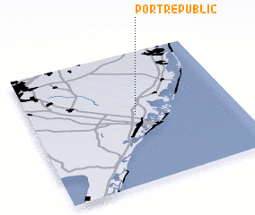 Places with similar names to Port Republic, United States - USA ::
// Port Republic (US)
// Port Republic (US)
Disclaimer :: Information on this page comes without warranty of any kind |
||
|
Where is Port Republic? Elevation and coordinates ::
Latitude (lat): 39°31'14"N Longitude (lon): 74°29'10"W
Elevation (approx.): 7m (map arrows pan, magnifying glasses zoom) |
||
|
Visiting Port Republic? Hotel/Accommodation ::
Book a hotel in Port Republic Travel Guide ::
rental cars ::
car rental offers GPS waypoint ::
download a GPX waypoint (PoI) of Port Republic for your GPS receiver
|
||