|
search place name
|
||
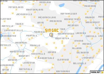
Singac (New Jersey, United States - USA)Singac is a town in the New Jersey region of United States - USA. An overview map of the region around Singac is displayed below.
regional and 3d topo map of Singac, United States - USA ::
Singac airports ::
The nearest airport is TEB - Teterboro, located 15.8 km east of Singac.
Other airports nearby include EWR - Newark Liberty Intl (22.4 km south), LGA - New York La Guardia (33.4 km east), JFK - New York John F Kennedy Intl (47.7 km south east), HPN - White Plains Westchester Co (49.2 km north east), Nearby towns ::
Meadow Village (2.1km south) //
North Caldwell (2.8km south west) //
Great Notch (3.1km south east) //
Totowa (3.3km north east) //
Cedar Grove (4.0km south) //
Two Bridges (3.2km west) //
Little Falls (3.4km south east) //
Mountain View (4.0km north west) //
Preakness (5.0km north) //
West Paterson (3.9km east) //
Montclair Heights (4.6km south east) //
Wayne (5.2km north west) //
Upper Montclair (5.6km south east) //
Verona (6.3km south) //
Packanack Lake (6.3km north) //
Caldwell (6.0km south west) //
Franklin (6.0km south west) //
Fairfield (5.5km west) //
Albion Place (5.5km east) //
Montclair (7.3km south) //
Richfield (6.1km east) //
Lincoln Park (6.6km north west) //
Westville (6.8km south west) //
Haledon (7.1km north east) //
Clinton (6.3km west) //
Paterson (6.7km north east) //
Essex Fells (7.8km south west) //
West Caldwell (7.2km south west) //
Brookdale (7.7km south east) //
[all distances 'as the bird flies' and approximate]  Places with similar names to Singac, United States - USA ::
Disclaimer :: Information on this page comes without warranty of any kind |
||
|
Where is Singac? Elevation and coordinates ::
Latitude (lat): 40°53'12"N Longitude (lon): 74°14'29"W
Elevation (approx.): 51m (map arrows pan, magnifying glasses zoom) |
||
|
Visiting Singac? Hotel/Accommodation ::
Book a hotel in Singac Travel Guide ::
rental cars ::
car rental offers GPS waypoint ::
download a GPX waypoint (PoI) of Singac for your GPS receiver
|
||