|
search place name
|
||
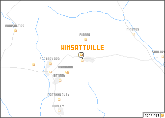
Wimsattville (New Mexico, United States - USA)Wimsattville is a town in the New Mexico region of United States - USA. An overview map of the region around Wimsattville is displayed below.
regional and 3d topo map of Wimsattville, United States - USA ::
Wimsattville airports ::
The nearest airport is TCS - Truth Or Consequences Muni, located 89.7 km north east of Wimsattville.
Other airports nearby include HMN - Alamogordo Holloman Afb (185.2 km east), BIF - El Paso Biggs Aaf (192.3 km south east), ELP - El Paso Intl (195.1 km south east), CJS - Ciudad Juarez Abraham Gonzalez Intl (202.9 km south east), Nearby towns ::
Turnerville (0.4km south) //
Hanover (1.1km north west) //
Union Hill (3.3km north) //
Cobre (3.8km south west) //
Fierro (4.5km north) //
Hanover Junction (4.2km south west) //
Vanadium (4.3km south west) //
Bayard (6.5km south west) //
Fort Bayard (6.2km west) //
Santa Clara (6.8km south west) //
[all distances 'as the bird flies' and approximate] 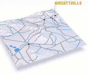 Places with similar names to Wimsattville, United States - USA :: Disclaimer :: Information on this page comes without warranty of any kind |
||
|
Where is Wimsattville? Elevation and coordinates ::
Latitude (lat): 32°48'20"N Longitude (lon): 108°5'2"W
Elevation (approx.): 1942m (map arrows pan, magnifying glasses zoom) |
||
|
Visiting Wimsattville? Hotel/Accommodation ::
Book a hotel in Wimsattville Travel Guide ::
rental cars ::
car rental offers GPS waypoint ::
download a GPX waypoint (PoI) of Wimsattville for your GPS receiver
|
||