|
search place name
|
||
East Eden (New York, United States - USA)East Eden is a town in the New York region of United States - USA. An overview map of the region around East Eden is displayed below.
regional and 3d topo map of East Eden, United States - USA ::

East Eden airports ::
The nearest airport is BUF - Buffalo Niagara Intl, located 31.4 km north of East Eden.
Other airports nearby include IAG - Niagara Falls Intl (49.9 km north), YHM - Hamilton (106.5 km north west), ROC - Greater Rochester Intl (106.9 km north east), YTZ - Toronto City Centre (116.3 km north west), Nearby towns ::
Water Valley (4.7km north west) //
Eden Valley (3.9km west) //
Clarksburg (5.2km south) //
Hamburg (5.5km north) //
Creekside (4.6km north east) //
North Boston (4.7km north east) //
Forest Glen (7.4km north) //
Eden (5.9km west) //
Scranton (8.2km north) //
Armor (8.5km north) //
Langford (8.9km south) //
Patchin (6.6km east) //
New Oregon (9.2km south) //
Wanakah (10.8km north west) //
[all distances 'as the bird flies' and approximate] 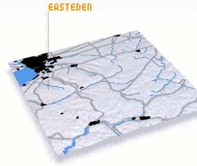 Places with similar names to East Eden, United States - USA ::
Disclaimer :: Information on this page comes without warranty of any kind |
||
|
Where is East Eden? Elevation and coordinates ::
Latitude (lat): 42°40'0"N Longitude (lon): 78°49'40"W
Elevation (approx.): 331m (map arrows pan, magnifying glasses zoom) |
||
|
Visiting East Eden? Hotel/Accommodation ::
Book a hotel in East Eden Travel Guide ::
rental cars ::
car rental offers GPS waypoint ::
download a GPX waypoint (PoI) of East Eden for your GPS receiver
|
||