|
search place name
|
||
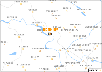
Hankins (New York, United States - USA)Hankins is a town in the New York region of United States - USA. An overview map of the region around Hankins is displayed below.
regional and 3d topo map of Hankins, United States - USA ::
Hankins airports ::
The nearest airport is SWF - Newburgh Stewart Intl, located 88.8 km south east of Hankins.
Other airports nearby include TEB - Teterboro (137.3 km south east), HPN - White Plains Westchester Co (142.1 km south east), EWR - Newark Liberty Intl (146.4 km south east), ALB - Albany Intl (148.4 km north east), Nearby towns ::
Mileses (3.0km north east) //
Stalker (3.1km north west) //
Basket (4.3km north west) //
Fremont Center (4.8km north east) //
Callicoon (5.8km south east) //
Long Eddy (5.6km north west) //
Abrahamsville (6.3km south west) //
Pleasant Valley (5.3km east) //
Fernwood (6.9km north) //
Rock Valley (8.4km north) //
Hortonville (7.3km south east) //
Conklin Hill (8.6km south) //
Obernburg (7.4km north east) //
Galilee (9.8km south west) //
[all distances 'as the bird flies' and approximate] 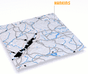 Places with similar names to Hankins, United States - USA ::
Disclaimer :: Information on this page comes without warranty of any kind |
||
|
Where is Hankins? Elevation and coordinates ::
Latitude (lat): 41°48'51"N Longitude (lon): 75°5'14"W
Elevation (approx.): 249m (map arrows pan, magnifying glasses zoom) |
||
|
Visiting Hankins? Hotel/Accommodation ::
Book a hotel in Hankins Travel Guide ::
rental cars ::
car rental offers GPS waypoint ::
download a GPX waypoint (PoI) of Hankins for your GPS receiver
|
||