|
search place name
|
||
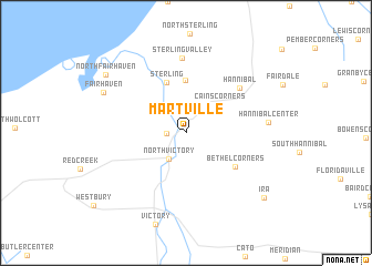
Martville (New York, United States - USA)Martville is a town in the New York region of United States - USA. An overview map of the region around Martville is displayed below.
regional and 3d topo map of Martville, United States - USA ::
Martville airports ::
The nearest airport is SYR - Syracuse Hancock Intl, located 46.3 km south east of Martville.
Other airports nearby include ROC - Greater Rochester Intl (86.8 km west), ART - Watertown Intl (93.0 km north east), YGK - Kingston (105.1 km north), GTB - Fort Drum Wheeler Sack Aaf (113.1 km north east), Nearby towns ::
Fintches Corners (1.4km west) //
North Victory (2.9km south west) //
Cains Corners (3.7km north east) //
Crocketts (5.3km north) //
Sterling (5.3km north) //
Bethel Corners (5.0km south east) //
Hannibal (6.0km north east) //
Sterling Valley (7.6km north) //
Hannibal Center (6.2km east) //
Fair Haven (7.3km north west) //
North Fair Haven (8.3km north west) //
Ira (8.7km south east) //
[all distances 'as the bird flies' and approximate] 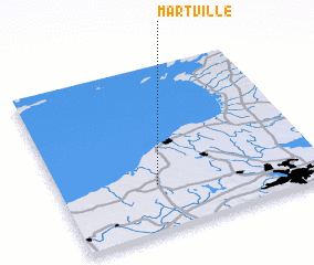 Places with similar names to Martville, United States - USA ::
// Mertvel' (RU)
// Marotavilo (MG)
// Mūrd-e Fal (IR)
// Mūrd-eFal (IR)
// Martvili (GE)
// Mortevielle (FR)
Disclaimer :: Information on this page comes without warranty of any kind |
||
|
Where is Martville? Elevation and coordinates ::
Latitude (lat): 43°16'48"N Longitude (lon): 76°37'39"W
Elevation (approx.): 117m (map arrows pan, magnifying glasses zoom) |
||
|
Visiting Martville? Hotel/Accommodation ::
Book a hotel in Martville Travel Guide ::
rental cars ::
car rental offers GPS waypoint ::
download a GPX waypoint (PoI) of Martville for your GPS receiver
|
||