|
search place name
|
||
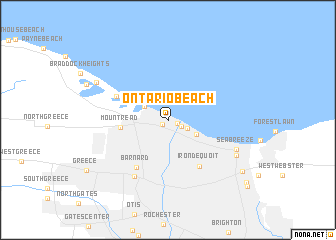
Ontario Beach (New York, United States - USA)Ontario Beach is a town in the New York region of United States - USA. An overview map of the region around Ontario Beach is displayed below.
regional and 3d topo map of Ontario Beach, United States - USA ::
Ontario Beach airports ::
The nearest airport is ROC - Greater Rochester Intl, located 16.4 km south of Ontario Beach.
Other airports nearby include YTR - Trenton (95.7 km north), BUF - Buffalo Niagara Intl (97.9 km west), IAG - Niagara Falls Intl (109.8 km west), SYR - Syracuse Hancock Intl (123.5 km east), Nearby towns ::
Charlotte (0.7km south west) //
Summerville (0.9km south east) //
Windsor Beach (1.3km south east) //
White City (1.8km south east) //
Rigney Bluff (2.4km north west) //
Rock Beach (2.9km south east) //
Island Cottage Beach (3.5km north west) //
Mount Read (4.0km west) //
Irondequoit (5.8km south east) //
Crescent Beach (4.9km north west) //
Barnard (5.9km south west) //
Uptonville (6.9km south west) //
Sea Breeze (6.5km south east) //
German Village (6.9km south east) //
Grand View Beach (7.2km north west) //
Newport (8.3km south east) //
Bay View (9.4km south east) //
Glen Haven (9.9km south east) //
[all distances 'as the bird flies' and approximate] 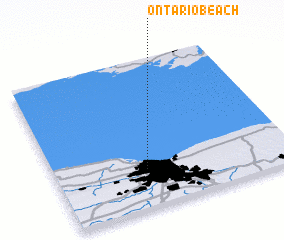 Places with similar names to Ontario Beach, United States - USA :: Disclaimer :: Information on this page comes without warranty of any kind |
||
|
Where is Ontario Beach? Elevation and coordinates ::
Latitude (lat): 43°15'36"N Longitude (lon): 77°36'41"W
Elevation (approx.): 81m (map arrows pan, magnifying glasses zoom) |
||
|
Visiting Ontario Beach? Hotel/Accommodation ::
Book a hotel in Ontario Beach Travel Guide ::
rental cars ::
car rental offers GPS waypoint ::
download a GPX waypoint (PoI) of Ontario Beach for your GPS receiver
|
||