|
search place name
|
||
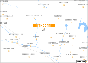
Smith Corner (New York, United States - USA)Smith Corner is a town in the New York region of United States - USA. An overview map of the region around Smith Corner is displayed below.
regional and 3d topo map of Smith Corner, United States - USA ::
Smith Corner airports ::
The nearest airport is ALB - Albany Intl, located 39.9 km north east of Smith Corner.
Other airports nearby include SWF - Newburgh Stewart Intl (106.8 km south), BDL - Windsor Locks Bradley Intl (130.9 km south east), CEF - Chicopee Falls Westover Arb Metropolitan (132.6 km east), HFD - Hartford Brainard (144.8 km south east), Nearby towns ::
Lambs Corner (3.4km south east) //
Medusa (4.0km south west) //
Rensselaerville (6.4km north west) //
Norton Hill (6.6km south east) //
Westerlo (7.2km north east) //
Oak Hill (7.5km south west) //
South Westerlo (6.4km east) //
West Greenville (7.8km south east) //
Greenville (8.5km south east) //
Durham (9.4km south west) //
[all distances 'as the bird flies' and approximate] 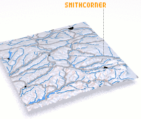 Places with similar names to Smith Corner, United States - USA ::
// Smith Corner (US)
// Smith Corner (US)
// Smith Corner (US)
// Smith Corner (US)
// Smith Corner (US)
// Smith Corner (US)
Disclaimer :: Information on this page comes without warranty of any kind |
||
|
Where is Smith Corner? Elevation and coordinates ::
Latitude (lat): 42°27'55"N Longitude (lon): 74°6'5"W
Elevation (approx.): 357m (map arrows pan, magnifying glasses zoom) |
||
|
Visiting Smith Corner? Hotel/Accommodation ::
Book a hotel in Smith Corner Travel Guide ::
rental cars ::
car rental offers GPS waypoint ::
download a GPX waypoint (PoI) of Smith Corner for your GPS receiver
|
||