|
search place name
|
||
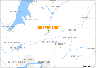
West Fort Ann (New York, United States - USA)West Fort Ann is a town in the New York region of United States - USA. An overview map of the region around West Fort Ann is displayed below.
regional and 3d topo map of West Fort Ann, United States - USA ::
West Fort Ann airports ::
The nearest airport is ALB - Albany Intl, located 75.8 km south of West Fort Ann.
Other airports nearby include BTV - Burlington Intl (122.8 km north), CEF - Chicopee Falls Westover Arb Metropolitan (159.6 km south east), BDL - Windsor Locks Bradley Intl (179.0 km south east), MSS - Massena Intl Richards Fld (197.7 km north west), Nearby towns ::
Tripoli (2.2km south) //
Vaughns Corners (4.3km south) //
Pattens Mills (3.9km south west) //
Queensbury (4.8km south west) //
Kingsbury (6.2km south east) //
Oneida Corners (5.9km south west) //
Brayton (6.2km north west) //
Lake Sunnyside (6.6km south west) //
Rockhurst (8.7km north west) //
Cleverdale (9.3km north west) //
[all distances 'as the bird flies' and approximate] 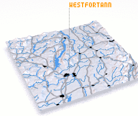 Places with similar names to West Fort Ann, United States - USA ::
// West Overton (US)
Disclaimer :: Information on this page comes without warranty of any kind |
||
|
Where is West Fort Ann? Elevation and coordinates ::
Latitude (lat): 43°24'35"N Longitude (lon): 73°34'27"W
Elevation (approx.): 142m (map arrows pan, magnifying glasses zoom) |
||
|
Visiting West Fort Ann? Hotel/Accommodation ::
Book a hotel in West Fort Ann Travel Guide ::
rental cars ::
car rental offers GPS waypoint ::
download a GPX waypoint (PoI) of West Fort Ann for your GPS receiver
|
||