|
search place name
|
||
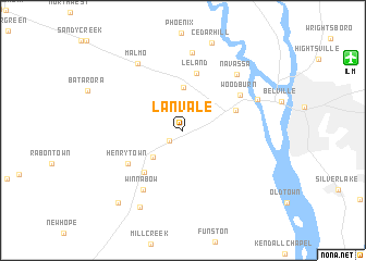
Lanvale (North Carolina, United States - USA)Lanvale is a town in the North Carolina region of United States - USA. An overview map of the region around Lanvale is displayed below.
regional and 3d topo map of Lanvale, United States - USA ::
Lanvale airports ::
The nearest airport is ILM - Wilmington Intl, located 16.1 km north east of Lanvale.
Other airports nearby include NCA - Jacksonville New River Mcas (79.7 km north east), MYR - Myrtle Beach Intl (99.3 km south west), GSB - Goldsboro Seymour Johnson Afb (126.3 km north), NKT - Cherry Point Mcas (132.8 km north east), Nearby towns ::
Spring Hill (1.5km south west) //
Bishop (3.8km south west) //
Eliah (4.4km north) //
Easy Hill (4.9km north east) //
Town Creek (5.4km south west) //
Leland (5.9km north) //
Henrytown (5.8km south west) //
Woodburn (6.0km north east) //
Winnabow (6.9km south west) //
Navassa (7.3km north east) //
Eastbrook (8.1km north) //
Clairmont (7.1km north east) //
Malmo (7.9km north west) //
Bell Swamp (8.6km south west) //
Russells Creek (9.2km south west) //
[all distances 'as the bird flies' and approximate]  Places with similar names to Lanvale, United States - USA ::
// Laneville (US)
// Lineville (US)
// Lone Valley (US)
// Leona Valley (US)
// Long Hill (US)
// Long Hill (US)
// Long Hill (US)
// Lyneville (US)
// Lunaville (US)
// Lenville (US)
Disclaimer :: Information on this page comes without warranty of any kind |
||
|
Where is Lanvale? Elevation and coordinates ::
Latitude (lat): 34°12'13"N Longitude (lon): 78°3'26"W
Elevation (approx.): 10m (map arrows pan, magnifying glasses zoom) |
||
|
Visiting Lanvale? Hotel/Accommodation ::
Book a hotel in Lanvale Travel Guide ::
rental cars ::
car rental offers GPS waypoint ::
download a GPX waypoint (PoI) of Lanvale for your GPS receiver
|
||