|
search place name
|
||
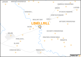
Lowell Mill (North Carolina, United States - USA)Lowell Mill is a town in the North Carolina region of United States - USA. An overview map of the region around Lowell Mill is displayed below.
regional and 3d topo map of Lowell Mill, United States - USA ::
Lowell Mill airports ::
The nearest airport is GSB - Goldsboro Seymour Johnson Afb, located 31.1 km south east of Lowell Mill.
Other airports nearby include RDU - Raleigh-durham Raleigh Durham Intl (66.4 km north west), POB - Fayetteville Pope Afb (89.1 km south west), EWN - New Bern Craven Co Rgnl (115.5 km south east), NCA - Jacksonville New River Mcas (115.7 km south east), Nearby towns ::
Bagley (1.4km north west) //
Beulahtown (3.2km north) //
Oak Grove Inn (2.7km west) //
Micro (4.0km west) //
Kenly (4.7km north east) //
Rains Crossroads (5.9km south) //
Hickory Crossroads (5.9km south east) //
Radford Crossroads (6.7km south east) //
Shoeheel (8.1km north west) //
Crumplers Crossroads (7.4km south west) //
Hollands Crossroads (8.1km south east) //
Kirbys Crossing (8.2km north east) //
Hawra (10.7km north east) //
[all distances 'as the bird flies' and approximate] 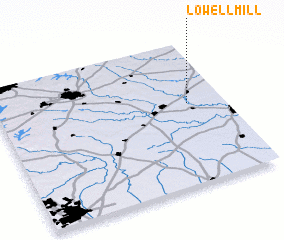 Places with similar names to Lowell Mill, United States - USA :: Disclaimer :: Information on this page comes without warranty of any kind |
||
|
Where is Lowell Mill? Elevation and coordinates ::
Latitude (lat): 35°33'59"N Longitude (lon): 78°9'40"W
Elevation (approx.): 53m (map arrows pan, magnifying glasses zoom) |
||
|
Visiting Lowell Mill? Hotel/Accommodation ::
Book a hotel in Lowell Mill Travel Guide ::
rental cars ::
car rental offers GPS waypoint ::
download a GPX waypoint (PoI) of Lowell Mill for your GPS receiver
|
||