|
search place name
|
||
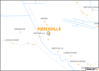
Pierceville (North Carolina, United States - USA)Pierceville is a town in the North Carolina region of United States - USA. An overview map of the region around Pierceville is displayed below.
regional and 3d topo map of Pierceville, United States - USA ::
Pierceville airports ::
The nearest airport is ECG - Elizabeth City Cgas Rgnl, located 23.4 km south east of Pierceville.
Other airports nearby include NTU - Oceana Nas (47.4 km north east), ORF - Norfolk Intl (50.2 km north), NGU - Norfolk Ns (54.3 km north), LFI - Hampton Langley Afb (70.7 km north), Nearby towns ::
Johnsons Corner (1.6km south) //
Tar Corner (3.3km north) //
South Mills (3.0km west) //
Lilly (4.2km north) //
Sharon (5.4km north) //
Burnt Mills (6.5km south east) //
Morgans Corners (6.1km south west) //
Jackson Corner (7.3km south west) //
Lambs Corner (10.0km south east) //
[all distances 'as the bird flies' and approximate] 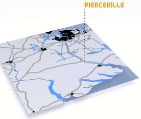 Places with similar names to Pierceville, United States - USA ::
// Priceville (US)
// Paris Villa (US)
// Pierceville (US)
// Perrysville (US)
// Pierceville (US)
// Prowsville (US)
// Pierceville (US)
// Pierceville (US)
// Priceville (US)
// Parrsville (US)
Disclaimer :: Information on this page comes without warranty of any kind |
||
|
Where is Pierceville? Elevation and coordinates ::
Latitude (lat): 36°26'54"N Longitude (lon): 76°17'38"W
Elevation (approx.): 9m (map arrows pan, magnifying glasses zoom) |
||
|
Visiting Pierceville? Hotel/Accommodation ::
Book a hotel in Pierceville Travel Guide ::
rental cars ::
car rental offers GPS waypoint ::
download a GPX waypoint (PoI) of Pierceville for your GPS receiver
|
||