|
search place name
|
||
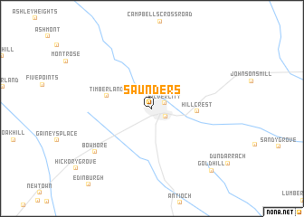
Saunders (North Carolina, United States - USA)Saunders is a town in the North Carolina region of United States - USA. An overview map of the region around Saunders is displayed below.
regional and 3d topo map of Saunders, United States - USA ::
Saunders airports ::
The nearest airport is POB - Fayetteville Pope Afb, located 28.7 km north east of Saunders.
Other airports nearby include FLO - Florence Rgnl (99.7 km south west), RDU - Raleigh-durham Raleigh Durham Intl (106.7 km north), GSB - Goldsboro Seymour Johnson Afb (122.8 km east), ILM - Wilmington Intl (146.3 km south east), Nearby towns ::
Silver City (1.4km north east) //
Raeford (1.8km south east) //
Hillcrest (4.6km east) //
Timberland (4.8km west) //
Bowmore (7.9km south west) //
Gold Hill (9.8km south east) //
[all distances 'as the bird flies' and approximate]  Places with similar names to Saunders, United States - USA ::
// Sania Torres (MA)
// Santa Rosa (BR)
// Santa Rosa (BR)
// Santa Rosa (BR)
// Santa Rosa (BR)
// Santa Rosa (BR)
// Santa Rosa (BR)
// Santa Rosa (BR)
// Santa Rosa (BR)
// Santa Rosa (BR)
Disclaimer :: Information on this page comes without warranty of any kind |
||
|
Where is Saunders? Elevation and coordinates ::
Latitude (lat): 34°59'25"N Longitude (lon): 79°14'24"W
Elevation (approx.): 86m (map arrows pan, magnifying glasses zoom) |
||
|
Visiting Saunders? Hotel/Accommodation ::
Book a hotel in Saunders Travel Guide ::
rental cars ::
car rental offers GPS waypoint ::
download a GPX waypoint (PoI) of Saunders for your GPS receiver
|
||