|
search place name
|
||
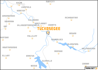
Tuckasegee (North Carolina, United States - USA)Tuckasegee is a town in the North Carolina region of United States - USA. An overview map of the region around Tuckasegee is displayed below.
regional and 3d topo map of Tuckasegee, United States - USA ::
Tuckasegee airports ::
The nearest airport is AND - Andersen Anderson Rgnl, located 94.0 km south east of Tuckasegee.
Other airports nearby include TYS - Knoxville Mc Ghee Tyson (99.2 km north west), HKY - Hickory Rgnl (165.7 km east), MGE - Marietta Dobbins Arb (Atlanta Nas) (197.3 km south west), ATL - Hartsfield Jackson Atlanta Intl (217.3 km south west), Nearby towns ::
Cowarts (3.1km north) //
Indian Place (3.7km south east) //
East Laport (4.3km north west) //
Fallcliff (5.4km west) //
Speedwell (6.1km west) //
Cullowhee (6.9km north west) //
Big Ridge (7.7km south east) //
Village of Forest Hills (7.1km north west) //
Rich Mountain (9.0km north east) //
Erastus (10.7km south west) //
[all distances 'as the bird flies' and approximate] 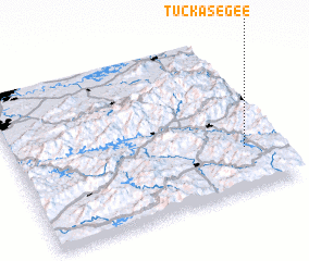 Places with similar names to Tuckasegee, United States - USA ::
Disclaimer :: Information on this page comes without warranty of any kind |
||
|
Where is Tuckasegee? Elevation and coordinates ::
Latitude (lat): 35°16'13"N Longitude (lon): 83°7'22"W
Elevation (approx.): 657m (map arrows pan, magnifying glasses zoom) |
||
|
Visiting Tuckasegee? Hotel/Accommodation ::
Book a hotel in Tuckasegee Travel Guide ::
rental cars ::
car rental offers GPS waypoint ::
download a GPX waypoint (PoI) of Tuckasegee for your GPS receiver
|
||