|
search place name
|
||
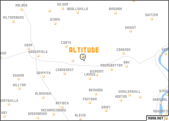
Altitude (Ohio, United States - USA)Altitude is a town in the Ohio region of United States - USA. An overview map of the region around Altitude is displayed below.
regional and 3d topo map of Altitude, United States - USA ::
Altitude airports ::
The nearest airport is PIT - Pittsburgh (pennsylva) Pittsburgh Intl, located 106.1 km north east of Altitude.
Other airports nearby include EKN - Elkins Randolph Co Jennings Randolph (139.0 km south east), AKR - Akron Fulton Intl (147.5 km north), CMH - Port Columbus Intl (162.1 km west), LCK - Columbus Rickenbacker Intl (163.3 km west), Nearby towns ::
Mount Carrick (2.0km west) //
Laings (4.1km south) //
Six Point (3.9km south east) //
Coats (4.3km north west) //
Cranenest (4.4km south west) //
Round Bottom (5.0km south east) //
Benwood (7.7km south) //
Cameron (6.9km east) //
Ozark (9.6km north west) //
Morton (10.9km south east) //
[all distances 'as the bird flies' and approximate] 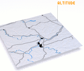 Places with similar names to Altitude, United States - USA ::
Disclaimer :: Information on this page comes without warranty of any kind |
||
|
Where is Altitude? Elevation and coordinates ::
Latitude (lat): 39°45'11"N Longitude (lon): 81°1'25"W
Elevation (approx.): 403m (map arrows pan, magnifying glasses zoom) |
||
|
Visiting Altitude? Hotel/Accommodation ::
Book a hotel in Altitude Travel Guide ::
rental cars ::
car rental offers GPS waypoint ::
download a GPX waypoint (PoI) of Altitude for your GPS receiver
|
||