|
search place name
|
||
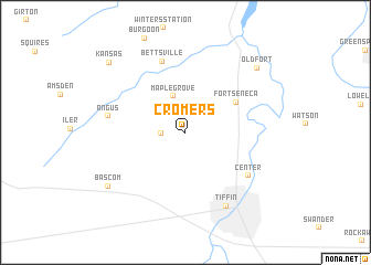
Cromers (Ohio, United States - USA)Cromers is a town in the Ohio region of United States - USA. An overview map of the region around Cromers is displayed below.
regional and 3d topo map of Cromers, United States - USA ::
Cromers airports ::
The nearest airport is DTW - Detroit Metro Wayne Co, located 115.1 km north of Cromers.
Other airports nearby include CLE - Cleveland Hopkins Intl (117.2 km east), YIP - Detroit Willow Run (120.2 km north), YQG - Windsor (123.4 km north), CMH - Port Columbus Intl (134.3 km south), Nearby towns ::
Mount Gilead (1.9km west) //
Maple Grove (3.8km north) //
Fort Seneca (4.9km north east) //
Bettsville (7.4km north) //
Center (6.5km south east) //
Angus (6.1km west) //
Tiffin (8.1km south) //
Bascom (8.0km south west) //
Old Fort (8.5km north east) //
Kansas (9.1km north west) //
[all distances 'as the bird flies' and approximate] 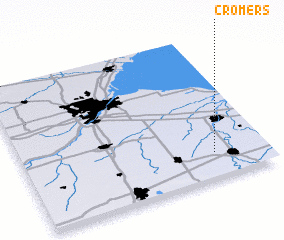 Places with similar names to Cromers, United States - USA ::
Disclaimer :: Information on this page comes without warranty of any kind |
||
|
Where is Cromers? Elevation and coordinates ::
Latitude (lat): 41°10'54"N Longitude (lon): 83°12'54"W
Elevation (approx.): 219m (map arrows pan, magnifying glasses zoom) |
||
|
Visiting Cromers? Hotel/Accommodation ::
Book a hotel in Cromers Travel Guide ::
rental cars ::
car rental offers GPS waypoint ::
download a GPX waypoint (PoI) of Cromers for your GPS receiver
|
||