|
search place name
|
||
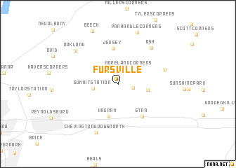
Fursville (Ohio, United States - USA)Fursville is a town in the Ohio region of United States - USA. An overview map of the region around Fursville is displayed below.
regional and 3d topo map of Fursville, United States - USA ::
Fursville airports ::
The nearest airport is CMH - Port Columbus Intl, located 15.0 km west of Fursville.
Other airports nearby include LCK - Columbus Rickenbacker Intl (27.7 km south west), FFO - Dayton Wright Patterson Afb (115.6 km west), DAY - James M Cox Dayton Intl (128.9 km west), AKR - Akron Fulton Intl (156.2 km north east), Nearby towns ::
Columbia Center (1.8km east) //
Moreland Corners (2.8km north east) //
Summit Station (3.1km west) //
Pataskala (3.7km east) //
Wagram (5.3km south) //
Jersey (5.7km north) //
Etna (5.9km south east) //
Beechwood Trails (6.0km east) //
Ash (7.1km north east) //
Chevington Woods North (8.2km south) //
Oakland (7.5km north west) //
Panhandle Corners (8.5km north) //
Beech (9.0km north) //
[all distances 'as the bird flies' and approximate]  Places with similar names to Fursville, United States - USA ::
// Frisvoll (NO)
// Fearisville (US)
// Fearsville (US)
// Fuersville (US)
// Freysville (US)
// Friesville (US)
// Frysville (US)
// Farrsville (US)
// Var-e Soflá (IR)
// Ferceval (HT)
Disclaimer :: Information on this page comes without warranty of any kind |
||
|
Where is Fursville? Elevation and coordinates ::
Latitude (lat): 40°0'11"N Longitude (lon): 82°42'59"W
Elevation (approx.): 319m (map arrows pan, magnifying glasses zoom) |
||
|
Visiting Fursville? Hotel/Accommodation ::
Book a hotel in Fursville Travel Guide ::
rental cars ::
car rental offers GPS waypoint ::
download a GPX waypoint (PoI) of Fursville for your GPS receiver
|
||