|
search place name
|
||
Heslop (Ohio, United States - USA)Heslop is a town in the Ohio region of United States - USA. An overview map of the region around Heslop is displayed below.
regional and 3d topo map of Heslop, United States - USA ::

Heslop airports ::
The nearest airport is PIT - Pittsburgh (pennsylva) Pittsburgh Intl, located 140.7 km north east of Heslop.
Other airports nearby include EKN - Elkins Randolph Co Jennings Randolph (141.5 km south east), LCK - Columbus Rickenbacker Intl (144.8 km west), CMH - Port Columbus Intl (147.8 km west), AKR - Akron Fulton Intl (169.7 km north), Nearby towns ::
Steel Run (3.1km south east) //
Dart (3.4km south) //
Gasville (3.2km north west) //
Wingett Run (4.2km north east) //
Fay (5.3km south) //
Moss Run (5.4km south west) //
Dalzell (5.7km north) //
Shay (5.8km east) //
Cow Run (7.9km south) //
Germantown (8.1km north) //
Gracey (8.6km south) //
Schley (8.5km south) //
Archers Fork (7.7km south east) //
Sitka (8.9km south west) //
[all distances 'as the bird flies' and approximate] 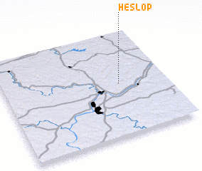
Disclaimer :: Information on this page comes without warranty of any kind |
||
|
Where is Heslop? Elevation and coordinates ::
Latitude (lat): 39°30'57"N Longitude (lon): 81°17'4"W
Elevation (approx.): 213m (map arrows pan, magnifying glasses zoom) |
||
|
Visiting Heslop? Hotel/Accommodation ::
Book a hotel in Heslop Travel Guide ::
rental cars ::
car rental offers GPS waypoint ::
download a GPX waypoint (PoI) of Heslop for your GPS receiver
|
||