|
search place name
|
||
Jacksonville (Ohio, United States - USA)Jacksonville is a town in the Ohio region of United States - USA. An overview map of the region around Jacksonville is displayed below.
regional and 3d topo map of Jacksonville, United States - USA ::

Jacksonville airports ::
The nearest airport is FFO - Dayton Wright Patterson Afb, located 21.5 km south west of Jacksonville.
Other airports nearby include DAY - James M Cox Dayton Intl (31.0 km west), LCK - Columbus Rickenbacker Intl (81.7 km east), CMH - Port Columbus Intl (83.2 km east), LUK - Cincinnati Muni Lunken Fld (106.2 km south west), Nearby towns ::
Rolling Terrace Mobile Home Park (0.9km south west) //
Shrine Road Mobile Home Park (1.4km south west) //
Rose Garden Mobile Home Park (1.9km north east) //
Snyders Mill (2.6km south) //
Happy Valley Mobile Home Park (2.8km north east) //
Lawrenceville (3.3km north) //
Dal-Mar Mobile Home Park (2.9km north east) //
Rock Way (3.7km south) //
Eagle City (3.3km north east) //
Clearview Mobile Home Park (5.0km south) //
Limestone City (5.3km south) //
Park Ridge Acres (5.8km south) //
Durbin (5.7km south west) //
Sunnyland (6.2km south) //
Edgewood Mobile Home Park (6.4km south) //
Tremont City (6.3km north east) //
Chateau Estates Mobile Home Park (5.4km north west) //
Springfield (6.1km south east) //
Bryar (7.4km north) //
Enon Heights Mobile Home Park (7.3km south) //
Karen Woods (8.3km south) //
Snyderville (7.6km south west) //
Beatty (8.8km south) //
North Hampton (7.3km north west) //
Glen Echo (7.7km north east) //
Pleasant Valley Estates Mobile Home Park (8.6km south west) //
Mad River (8.7km south west) //
Windy Corner (9.2km north west) //
Bowlusville (9.4km north east) //
[all distances 'as the bird flies' and approximate] 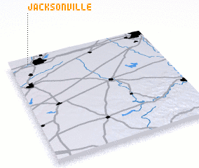 Places with similar names to Jacksonville, United States - USA ::
// Jacksonville (US)
// Jacksonville (US)
// Jacksonville (US)
// Jacksonville (US)
// Jacksonville (US)
// Jacksonville (US)
// Jacksonville (US)
// Jacksonville (US)
// Jacksonville (US)
// Jacksonville (US)
Disclaimer :: Information on this page comes without warranty of any kind |
||
|
Where is Jacksonville? Elevation and coordinates ::
Latitude (lat): 39°57'31"N Longitude (lon): 83°51'53"W
Elevation (approx.): 328m (map arrows pan, magnifying glasses zoom) |
||
|
Visiting Jacksonville? Hotel/Accommodation ::
Book a hotel in Jacksonville Travel Guide ::
rental cars ::
car rental offers GPS waypoint ::
download a GPX waypoint (PoI) of Jacksonville for your GPS receiver
|
||