|
search place name
|
||
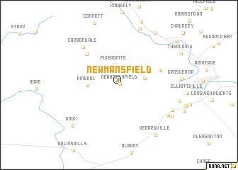
New Mansfield (Ohio, United States - USA)New Mansfield is a town in the Ohio region of United States - USA. An overview map of the region around New Mansfield is displayed below.
regional and 3d topo map of New Mansfield, United States - USA ::
New Mansfield airports ::
The nearest airport is LCK - Columbus Rickenbacker Intl, located 81.6 km north west of New Mansfield.
Other airports nearby include CMH - Port Columbus Intl (94.5 km north west), FFO - Dayton Wright Patterson Afb (166.7 km west), DAY - James M Cox Dayton Intl (183.3 km west), AKR - Akron Fulton Intl (200.8 km north), Nearby towns ::
New Marshfield (0.2km north east) //
Five Points (3.2km north) //
Luhrig (3.3km east) //
Mineral (3.8km west) //
Brookville (5.6km north east) //
Hocking (6.3km north west) //
Carbondale (7.4km north west) //
Fullview Heights (7.7km south east) //
Rolling Hills (7.6km south east) //
Fisher (8.1km south east) //
Knox (8.6km south west) //
Hebardville (9.0km south east) //
Hamley Run (9.3km north east) //
[all distances 'as the bird flies' and approximate] 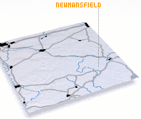 Places with similar names to New Mansfield, United States - USA :: Disclaimer :: Information on this page comes without warranty of any kind |
||
|
Where is New Mansfield? Elevation and coordinates ::
Latitude (lat): 39°19'26"N Longitude (lon): 82°13'12"W
Elevation (approx.): 255m (map arrows pan, magnifying glasses zoom) |
||
|
Visiting New Mansfield? Hotel/Accommodation ::
Book a hotel in New Mansfield Travel Guide ::
rental cars ::
car rental offers GPS waypoint ::
download a GPX waypoint (PoI) of New Mansfield for your GPS receiver
|
||