|
search place name
|
||
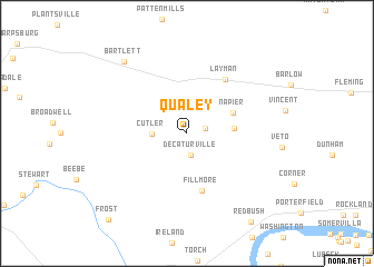
Qualey (Ohio, United States - USA)Qualey is a town in the Ohio region of United States - USA. An overview map of the region around Qualey is displayed below.
regional and 3d topo map of Qualey, United States - USA ::
Qualey airports ::
The nearest airport is LCK - Columbus Rickenbacker Intl, located 112.6 km north west of Qualey.
Other airports nearby include CMH - Port Columbus Intl (120.6 km north west), EKN - Elkins Randolph Co Jennings Randolph (172.4 km east), PIT - Pittsburgh (pennsylva) Pittsburgh Intl (181.5 km north east), AKR - Akron Fulton Intl (188.5 km north), Nearby towns ::
Dunbar (1.5km east) //
Decaturville (2.2km south) //
Cutler (2.7km west) //
Tick Ridge (3.7km east) //
Napier (4.2km north east) //
Fillmore (5.8km south) //
Layman (6.2km north east) //
Bartlett (8.7km north west) //
Redbush (10.2km south east) //
Frost (10.6km south west) //
[all distances 'as the bird flies' and approximate] 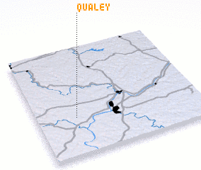 Places with similar names to Qualey, United States - USA ::
Disclaimer :: Information on this page comes without warranty of any kind |
||
|
Where is Qualey? Elevation and coordinates ::
Latitude (lat): 39°21'17"N Longitude (lon): 81°45'31"W
Elevation (approx.): 230m (map arrows pan, magnifying glasses zoom) |
||
|
Visiting Qualey? Hotel/Accommodation ::
Book a hotel in Qualey Travel Guide ::
rental cars ::
car rental offers GPS waypoint ::
download a GPX waypoint (PoI) of Qualey for your GPS receiver
|
||