|
search place name
|
||
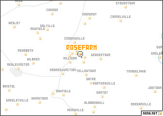
Rose Farm (Ohio, United States - USA)Rose Farm is a town in the Ohio region of United States - USA. An overview map of the region around Rose Farm is displayed below.
regional and 3d topo map of Rose Farm, United States - USA ::
Rose Farm airports ::
The nearest airport is LCK - Columbus Rickenbacker Intl, located 73.3 km west of Rose Farm.
Other airports nearby include CMH - Port Columbus Intl (75.5 km north west), AKR - Akron Fulton Intl (153.6 km north), FFO - Dayton Wright Patterson Afb (169.1 km west), PIT - Pittsburgh (pennsylva) Pittsburgh Intl (178.3 km north east), Nearby towns ::
Tropic (0.6km east) //
Misco (1.0km south) //
Stringtown (1.4km north west) //
Conway Addition (1.9km north west) //
Flatiron (2.0km north west) //
Brigglesville (2.5km north) //
McLuney (2.1km west) //
Milligan (2.2km south west) //
Yellowtown (3.9km south) //
Crooksville (3.9km north) //
Deavertown (3.4km east) //
Moores Junction (4.9km south west) //
Sayre (5.9km south) //
Roseville (8.0km north) //
Portersville (7.9km south east) //
Oakfield (9.1km south) //
San Toy (9.6km south) //
Saltillo (8.9km north west) //
Moxahala (9.6km south west) //
[all distances 'as the bird flies' and approximate] 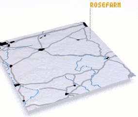 Places with similar names to Rose Farm, United States - USA :: Disclaimer :: Information on this page comes without warranty of any kind |
||
|
Where is Rose Farm? Elevation and coordinates ::
Latitude (lat): 39°44'9"N Longitude (lon): 82°4'41"W
Elevation (approx.): 235m (map arrows pan, magnifying glasses zoom) |
||
|
Visiting Rose Farm? Hotel/Accommodation ::
Book a hotel in Rose Farm Travel Guide ::
rental cars ::
car rental offers GPS waypoint ::
download a GPX waypoint (PoI) of Rose Farm for your GPS receiver
|
||